Greece Property for Sale - Real Estate In Greece Buy & Sell |
| Chania Property & Houses For Sale - Real Estate In Greece 1 Property(s) Found - Page 1 of 1 - Updated: 4/19/2024 |
Display by - Price:   Area: Bedrooms: Prop Type: Location: Area: Bedrooms: Prop Type: Location: | ||||||
|
FEATURED PROPERTIES: Ikaria - Armenistis New Maisonettes Price: €209,000 - 125 m2 Bedrooms: 3 Baths: 2  |
 Email Seller

Chania Crete
Crete's westernmost province is famous for the city of Hania, and for its natural beauty more than for its archaeological sites (though there are some) or for its beach resorts (of which there are few). Its nature is of a wild and rugged variety that doesn't accommodate the worst of tourism, though that there is as well, though more in the cities than by the beaches, the coast being rockier and less accessible. The city of Hania is usually described as Crete's most beautiful city. It's the largest city, and was the captital of Crete until 1971. Its harbor, with its Venetian and Turkish architecture, is one of the most popular subjects of photographs from Crete, and indeed it is a beautiful place. The northern coast has two large peninsulas, one smaller one, Akrotiri, with the large Bay of Souda just to the east of the city, where there is a NATO base and Rodhopou to the west, with its lush nature, quiet villages, serenity, and hiking possibilities. Gramvousa is a smaller peninsula to the far west, a wild, uninhabited place at the island's northwestern-most tip. Inland are the deservedly famous Lefka Ori, (The White Mountains), with their snowcapped peaks that are rarely out of sight from anywhere in the province, (including the city of Hania itself), with their equally famous gorges which draw vast numbers of hikers every summer. The mountain-hemmed, wild south coast with its bays, its rare sandy beaches, and the occasional resort such as Paleohora has its own unique beauty. Most of the tourism in this province is concentrated on the coast near Hania, leaving much to explore for those not fond of crowds. City of HaniaHistory
In 1897, during the late years of the War of Independence, Cretans raised the Greek flag, to be bombarded by the Great Powers (see section on Akrotiri). Though central Greece and some islands became a nation in 1830, only nine years after the Greek War of Independence began in the the Peloponnese, Crete was under the Ottoman empire until 1912 (along with Macedonia and Ipirus), not becoming part of Greece until 1913. During World War II most of the German landings and fighting was on the coast west of Hania and all but the old harbor area was wiped out by heavy bombardments compounded by a fire and the last six months of German occupation centered on Hania. The city was rebuilt after the war, and has, like all of Greeks cities, expanded in size and population since, to its present population of around 50,000 inhabitants, though it didn't become a tourist destination until the 1980s. Hania's LandmarksThe Outer Harbor
On the other end of the harbor from the mosque is the Naval Museum (open Tues-Sun 9am-4pm; 2euros), Though some of it is mostly of interest to those with a passion for naval battles and the like, the section on the Battle of Crete in 1941 is both fascinating and saddening (as it brings home the suffering endured here under the Nazis).
Behind the Naval museum is the Byzantine Museum (open Tues-Sun 8:30am-3pm;2euros; combined ticket with Archaeological Museum, 3euros). Icons, jewelry, mosaics. Of the remaining old city walls, the most intact are beyond hotel built on top of the fortifications, past which you can follow the walls on the inner side and see some of the best of old Hania, with narrow lanes and old Venetian houses. In between Theotokopoulou (a fine old street) and the waterfront at the bottom of Moschon is the beautiful Renieri Gate.
The Folklore Museum (Mon-Sat 9am-3pm and 6-9pm;1.50euros) is in a beautiful mansion in the same courtyard as the Roman Catholic Church. The Cathedral, set in a small square, was built during the last century, and is rather small and not terribly exciting, but above it on Odos Skridlof, is the fascinating street of traditional leather-workers where, despite concessions to tourism high Cretan boots are still made, as well as sturdy work shoes. To the east of here is the cross-shaped Market, said to be modelled on the market at Marseille, and dating from the early 1900s. Behind it is a little shady square. Quarters of Chania
Festivals and EventsThe Battle of Crete Festival commemorates the Battle of Crete; held during the last week of Mayat the Public Gardens, with folkdancing. Other Festivals as in most of Greece, churches and towns put on local festivals all-year-round. Getting to go to one is a matter of being in the right place at the right time and looking out for posters too. Sometimes the tourist offices will know something. The Cafe Harhalis Traditional Cretan Music Center
Though the music that happens at this wonderful cafι is a rather impromptu thing, you might be able to find out about some non-advertised events where Cretan music is happening, or connect with musicians and teachers if you are yourself a musician. The kafetzis (Manolis, by name) may give you a lesson right there (or call somebody up who will come give you one). For a wider selection of Cretan music recordings, look in Hania, Rethymno and Iraklio. Other traditional music places: Cafι Kriti Kalergon 22, corner of Andhroyio. Old style kafeneio with Cretan music and dancing almost every night. Skala Kalergon 12. Rembetika venue with all-night performances that begin after midnight. You might see posters for music events near the market or around town, and check to see if there are events at the Public Gardens. Be aware, however, that the words for 'traditional music' (paradhosiaka) doesn't always mean that you'll get to hear the older geuine article music, since, as with traditional music all over Greece, the old tunes have gotten slicked up in the world of commercial music, and further altered by extreme amplification complete with too much reverb, which makes the instruments sound muddy and unlike themselves. Beaches are all to the west of the city. Buses leave from the east side of Platia 1866. Good places to get out are Oasis or Kalamaki. See section on Coast west of Hania for more details. East of Hania
The site of this chapel was briefly occupied by the Revolutionary Military Camp of Akrotiri (Crete not liberated from Ottoman rule until 1912) and was within the 'exclusion zone' of the Great Powers (British, French, Italian, and Russian-all of which had navies at the bay there). They bombarded the Cretan resistance enclave in 1897, and the Cretan response was the raising of the Greek flag, much to the displeasure of the European super-powers, who shot at the flagpole. One account has it that the foreign admirals were so impressed by the courage of the Cretans (who held the flag up in their hands after the destruction of the flagpole) that they applauded. The chapel (which was a monastery at the time) was, however, then blown up by the Russians (though the following day the Russian ship itself was blown up, an event interpreted by the Cretans as the revenge of the Prophet Elijah). The Chania Airport & Beaches to Stavros
The present name means 'Holy Trinity' and on 'Trinity Sunday' a place of pilgrimage to which many travel from afar. There was a religious college here during the 19th century. The monastery has a fine library and an olive-oil factory run by the monks in one of the buildings.
The Allied War Cemetery is on other side of the isthmus (south side) from the Venizelous graves. Though on some maps the cemetery is named as 'The British Cemetery' and also 'The Commonwealth War Cemetery', the 1527 soldiers buried in the well-kept graves in this peaceful eucalyptus grove number 862 British, 5 Canadians, 197 Australians, 446 New Zealanders, 9 South Africans and 8 soldiers from other countries most of whom perished in the first days of the Battle of Crete during May of 1941, many of them very young and many unknown. The grave of British archaeologist John Pendlebury, successor to Sir Arthur Evans in the excavation of Knossos after Evan's retirement, is here, though Pendlebury died fighting during the German attack on Iraklion (in the eastern flank of the German coastal invasion. See the Battle of Crete in the West of Hania section. East of Souda Bay
Kalives, a fair-sized market town, is near here on the old road and nearby Almiridha, a smaller place and a resort with a nice beach. Wind-surfers come here, as well as local families.
East of Almiridha the coast road cuts inland a bit, one fork going out to the north tip of the Drapano Peninsula, and the other heading south through the peninsula itself, further inland from the seaside cliffs, where it stays until a side road reaches Yeorghioupolis. Cape Drapano
At Gavalohori there's a folklore museum (open 10am -1pm) with exhibits of old village life in a restored Venetian building with some later Turkish additions. Labels are in both Greek and English, and exhibits include wood-carving, stone-cutting, and silk-lace making (called 'kopaneli') a craft experiencing a revival in this village. The mulberry trees were planted by the Turks. The local Women's Agrotoruisim Coperative (one of two inspired by some of the historical exhibits), have resuscitated this old craft, long dormant., the first group working with ceramics and glass as well, with their products on sale. Byzantine wells are found outside of this town, and there is evidence that this was an ancient settlement. Some of the nicer villages on the cape are Dhrapanos, and Kefalas, with a lot of old stone-work. Kefalas has views of the sea on both sides. Before Vamos, the port of ancient Lappa (now Argyroupolis-see Rethymno province) is bigger, and in ways more modern, though it has nice shade trees, and nearby Aspro (which means 'white'), a truly lovely old village. Exopoli (almost to Georghioupoli, has great views of the sea below.
Water levels also change, dropping severely in late summer, which provides camping spots for many (though insects can be a problem, and paraphernalia for dealing with them is best brought along with you). Back towards the west
Continuing on the road (if you are driving) you'll pass through the ridge-top village of Sourva, with spectacular views, the beautiful village of Meskla below it in the Keritis valley, with a stream and fertile agricultural land with orange groves. There are some nice chapels around here, with frescoes. There is a much-repeated story (more of a legend) , about the Kandanolean revolt, said to have happened in Meskla, which is told differently by different people, the common thread being the wedding of a Cretan leader named Kandanoleon with a daughter of the Venetian nobility and the treachery on the part of the Venetians, who murdered the the drunken Cretan wedding guests, thus re-asserting Venetian hegemony. According to one version, the wedding was the Venetians idea, after a Cretan conquest-the offering of a noble Venetian bride an act to symbolize their submission to the Cretan victory-- but in fact a ruse, which ended with them drugging the wine of their victims and cutting their throats. Another version has it that Kandanoleon had been running a rebel government under Venetian rule, and himself arranged to marry his son to the daughter of a Venetian aristocrat. In this version the wedding guests got themselves adequately drunk enough to be captured as they slept and the leaders taken off and hanged. There's a large agricultural cooperative in Fournes farther down the road and the birthplace of Venizelos at Mournies. West of Hania on the Coast
The village of Galatas, has a small Battle of Crete museum, with a memorial outside. There's a marshland outside of this town with a reservoir with a large birdlife population.
A cave in the islet may have been a Minoan sanctuary. The islet was also a Venetian fortress. Platanias to the west has an old town with cliffside tavernas, some of them very atmospheric and as you can see from this photo left a rather nice beach.
The possession of this airfield enabled the Germans to bring in troops and supplies, and on the fourth day of the battle, German fighter planes were taking off from the runway there. The tide of the battle turned at this point, and some 18,000 Allied soldiers (mostly British, Australian and New Zealand troops) fled through the mountains to the sea to be evacuated, while perhaps 2000 were killed. There were also 12,000 taken prisoner. Strangely, the Australian commander Freyberg knew where the attacks would come (having cracked the German codes), and Allied troops could have been redeployed to retake the airfield. Why they weren't, is attributed by some to some form tragic incompetence.
Kolimbari (left) is a quiet and very undeveloped place, perhaps because its beach, though offering great views back along the coast, has no sand. There are, however, some rooms, and tavernas along the waterfront which the village itself a little further in. You can walk from here to the base of the peninsula. The Rhodopou Peninsula
There's a small museum, in which some of them are kept, and a chapel with others, as well as a 14th century church on the nearby cliffs, with frescoes. The little cove down below may well be restricted for use by the few monks still resident in the monastery, so you might want to ask before descending to take a swim. Afrata is very small, with a few kafeneia, but there's a paved road leading down to a cove near a gorge. Many people hike to the Church of Aghios Ioannis Gionis on the west side of the peninsula on 29 August (the saint's day of St. John the Baptist), a major pilgrimage for the religious, and for male babies named Yiannis (John), a time of collective baptism. The walk takes two or three hours (one way), leaving from Rodhopos, which has a paved road to it, though you can walk from a side road off the main road from Kolimbari, (see above in section about the Allied cemetery near Souda Bay). Inland Roads, Gorges, South CoastHora Sfakion - Imvros gorgeThe main road is south from Vrysses , which winds up on the Plateau of Askifou (about half-way to the south coast. This was the road where the evacuation of Allied troops happened after defeat by the Germans in the Battle of Crete in May, 1941. It is also the scene of the massacre of Turkish armies by the Cretans both at the beginning of the War of Independence in 1821, and in 1866 after the events at Arkhadhi Monastery (see Rethymno) during the same struggle. Villages on the plateau include Amoudhari, from which hikes in several directions are possible, one of them an arduous walk via Kali Lakki of 18km southwest to Anopoli (on the south coast just west of Hora Sfakion) Without explicit directions, this walk might be a bad idea, though. Other walks both east and west are easier, including one to the village of Atsigonia. Be aware in general that the Greek sense of time and distance is usually different from that of foreign visitors, and that details in trekking guides might be more reliable than the estimates of villagers, which often turn out to be a fraction of the reality (much to the chagrin of the unititated). From Anopoli, should you venture this hike, you can get to the Aradhena gorge to the west in about an hour. There are old paths that descend down one side and up the other, inland a bit. The village across the gorge is abandoned, but there's a Byzantine church there with some frescoes. There's a car road to, with a bridge across the gorge, which ends another 5km to the west at Aghios Ioannis. The coast trail (near Aghios Pavlos) will get you to Aghia Roumeli in about five hours (17km), though one might allow extra time. There's another hike from Loutro up the gorge and over the Anopoli, but the gorge is quite steep and only the very fit should tackle it. It is, however, a beautiful place. The Imvros Gorge
The gorge walk is a less crowded one than at Samaria, and is easily accomplished in about three hours, the trail beginning from the village of Imvros and following the stream all the way. There are caves, stone archways, and steep narrow passages where the cliffs converge, as at Samaria. When you come out, you walk west 5km to Hora Sfakion. There are many other gorges within the region as well including the Aradaina (right). Hora Sfakion This town is quite small, and though it has a lot of rooms and plenty of tourist facilities, there isn't much of a beach. There's a better beach at Sweetwater an hour to the west along a path by the water (accessible also by boat) and the Cave of Dhaskaloyiannis in the cliffs, named for the revolutionary leader (during the Greek War of Independence) who minted rebel coins there. Dhaskaloyiannis (dhaskalos meaning 'teacher' and 'Yiannis' the Greek equivalent of 'John) was born in Anopoli (see above) and was a wealthy shipowner who was promised support by the Russian if he staged a revolt in Sfakia, but the support wasn't forthcoming, and the 1770 revolt was a disaster, with its leader (who surrendered) brutally executed and Sfakia subjugated for the first time by the Turks. There are boats to the island of Gavdhos from here, which is the southernmost landmass in Europe (see details at end of Hania article). Frangokastello
The castle was built in 1371 against pirate incursions as well as for local control on the part of the Venetian (and later Turkish) rulers, 'Frango' meaning basically 'west European'. The walls (which are about all that remains of the castle) are pinkish orange in color. In 1828,during the first years of the Greek War of Independence, the castle was occupied by a rebel force made up of 650 Cretans under the leadership of a mainlander from the mountains of northwest mainland Greece (Ipirus) named Hadzimihali Daliani, who hoped to spread revolutionary fervor on the island of Crete. Their massacre by an army of 8000 Turks (revenged by Cretans hiding in the the mountain passes as the Turks left the coast) became a legend in these parts, the victims elevated to the status of martyrs and it has been reported by thousands that on 17 May (the anniversary of the massacre) or even later, during the last days of May, their ghosts of the slaughtered rebels rise up from their graves armed and mounted on horses, ride towards the castle and disappear into the sea. To Aghia Roumeli; Samaria gorgeThe road goes west out of Hania, then roughly south towards the Omalos plateau ('omalos' means navel in Greek). In the Kerkitis valley near Aghia are orange groves with windbreaks made of a type of cane commonly used for this purpose on many Greek islands. This area is known as Prison Valley since the days of the Battle of Crete (1941), because of the prison there (both then and now). During the German airborne invasion German parachutists tried to land in the valley as part of a pincer movement along with forces on the coast road in the planned attack on Hania, but were met with daunting resistance (as they were on the coast, where the German suffered horrific losses). There is a reservoir near Aghia, which is frequented by both birds and bird-watchers, spring migration being the best time season. There are churches, some of them with frescoes on the way to Omalos, in the Episcopi area, and also near the war memorial near the junction with the road to Soughia. There's a turnoff to the village of Meskla (see above) near Fournes After the main road crosses the Kerkitis River the road spirals up to Lakki, a tile-roofed mountain village with specactular views, and wonderful local honey. Beyond there the road reaches a pass, with a plaque commemorating the death of Sergeant Perkins, a New Zealand leader of a guerilla band during the World War II resistance and a Cretan co-fighter, who died in a German ambush in 1944, at the end of the war. Perkins, whose was nick-named 'Vasili' and 'Kiwi' had escaped from a prison camp early in the war, later from the island itself, and then returned as an undercover agent. He and his Cretan comrades were based in the southwest part of the island, and were much-sung heroes of the resistance.
The village of Omalos, has some tavernas and rooms, though it is inhabited only during the summer when some potatoes and grains are cultivated. In winter the place is snow-covered, and in spring, water-logged and boggy . A very remote place, this. From here there are trails to the southeast, to Kallergis mountain refuge (at 1680 meters, a place with 30 beds, open May-Oct), and from there to the peak of Paknes (2452meters), the latter just a few meters lower than the peak of Psiloritis (the highest peak on Crete). The total time for this hike is about nine hours. Trail to the Samaria gorge
The Samaria Gorge receives its own section. Serene places on Crete’s south coast
Sweetwater is about half of the distance to Hora Sfakion from Loutro and consists of a long narrow beach hemmed in by sheer cliffs. Small springs emerge from the pebbles on the beach, providing the delicious (very potable) freshwater that gives the place its name. More frequented in recent years due to daily boats from both Loutro and Hora Sfakion, it is still large enough to absorb a good number of visitors. Caves at the back of the beach are usually occupied by those who stay for long periods on the beach. A simple taverna is at the west end. It takes about three quarters of an hour to walk to Loutro from here and a bit longer to Hora Sfakion. This is a place that campers have respected (so far) in not leaving trash on the beach, and not using soap when digging holes to get freshwater, an ecological sensitivity that will hopefully continue. Ancient FinikasFinix, just to the west of Loutro on the other side of a promontory, is a rocky beach on a little bay with a taverna and some rooms; a simple, quiet place. Once ancient Finikas is was a significant town in both Roman and Byzantine times, and later an important port. There's a Venetian fortification up on the headland and traces of a Byzantine basilika, as well as a curious sunken buildin, nowadays used as a cistern, but resembling a Venetian church with an arched roof. Some think that it was an arsenal attached to the basilika. You can get to Finix from the path behind Loutro in about ten minutes. Supply boats headed for Marmara stop here too. Likkos, a little to the west of Finix, also has fresh water, but the beach is rocky and makes getting in the sea difficult. Up above it is the village of Livaniana, to the east of the Aradhena gorge, which reaches the sea at Marmara beach ('marmara' meaning 'marble'), a sandy beach with caves, and rock slabs to dive from. Too many boats from Loutra (three a day) bring too many people, though mostly during high season. You can camp here if willing to hike out and back for food and whatever else you need. Hikes starting at Loutro are generally in rugged country and some of them pretty isolated, the least so being the coastal path mentioned above, though it can be narrow and bumpy along cliff faces and hot in the summer sun. The easier hike is from Loutro to Hora Sfakion (less than two hours); Loutro to Aghia Roumeli is harder, and can take four hours. There are also inland routes from Aghia Roumeli to Hora Sfakion that pass through Anopoli (see section on road to Hora Sfakion above). The Aradhena gorge offers yet another route, from Loutro to Anopoli and down to Marmara Beach, but again, the terrain is rugged and tackled best by the very fit. Hania to SoughiaHania to Soughia From Hania, this route goes first to Omalos and from there west through Alikianos, to get past the high peaks. The war memorial here, mentioned above (Samaria section), honors the Cretans who fought on during the retreat of thousands of soldiers fleeing the coast after the tide had turned against the Allied forces there. It was these Cretan heroes who insured the success of the evacuation by preventing the Germans from cutting off the exit road. Alikianos was also the site of the wedding massacre that ended the Kandanoleon revolt. There is a 14th century church here with very intact 15th century frescoes. Skines is a nice village with a wide avenue and orange orchards. The ride between there and the Aghia Irini valley is a lovely drive past the forested hillsides of the Lefka Ori foothills. Aghia Irini is an village with old chesnut trees. There was a serious fire during the summer of 1994 between the gorge of the same name and Soughia, which burned villages as well as countryide. The road to the south coast from here goes southwest at this point to loop past several villages, and, the first sight of the Libyan Sea below you is from near Epanohori, after which the road passes through Prines and Tsikania to Kambanos. This region shows evidence of malachite mining in ancient times. Beyond Maralia, (hidden from the road) and past the junction for Rodhovani is a large modern church on the site of ancient Elyros, a major Roman city-state (though there's not much left of it). The site was rediscovered by an English scholar during the early 1800s. A 6th century basilika was found (where the present church now sits) which controlled the valley down to Soughia, (at that time Syia) which was one of its ports. During Byzantine times it was the seat of a bishop. The last village before the coast is Moni, with the 14th century frescoed church of Aghios Nikolaos, and the only known campanile on the island. A side road just past there takes you to the village of Koustoyerako which was the location of the aborted execution of women and children by a German platoon in 1943 , prevented by ten of the village guerillas for whom the Germans had been searching and who fired from a height above (at a distance of 400meters/1312 feet) killing ten Germans simultaneously with no bullet wasted, which sent the execution squad packing. The Germans returned the next day to find the village deserted, but blew up all the houses anyway. Kostas Paterakis, the guerilla who fired the first shot (which killed the machine-gunner) was still living there ten years ago and may still be alive. One of his relatives, Manolis, now deceased, was among the capturers of the German General Kreipe and the village itself has a history of resistance-to Venetians and Turks before the Germans. The failed execution is beautifully described in Yiorgos Psychoundakis' The Cretan Runner, in accounts by the Irish writer Patrick Leigh Fermor, (one of the foreigners who helped to capture General Kreipe) and in the book entitled Crete by A. Beevor. Koutsoyerako was also a village in ancient times, and the rebuilt modern is a beautiful one, situated beneath the mountains and overlooking the Libyan Sea. There's a war memorial there, as one would expect, and the cliffs from which the guerillas fired the shots that saved their women and children easily pointed out by the natives. The frescoed Byzantine chapel of Aghios Yiorghos, built possibly as early as the 10th century, is at the top of the village. It was restored during the 16th century, and inscriptions record many generations of the Kandanoleon family (see the story about the 'wedding massacre'near Meskla). There's a kalderimi (cobbled road) leading from the platia (square) to the summer pastures used by the village on Mount Akhlada ('akhladi' is a 'pear'), a walk taking about two hours. Soughia
The remains of the Dorian city of Lissos to the west, can be reached on foot in 1 ½ hours or less (a quarter hour by boat), the marked path beginning from behind the beach at the harbor and leading up a beautiful gorge, and then back towards the sea, where Lissos sits below you at the back side of a small bay. There is a medicinal spring here which pours from a cliff wall, and which was the site of a much visited 3rd century BC Askipion (healing sanctuary), remains of which reveal a pebble mosaic floor and a snake pit (uninhabited now). There were also an old theater, bath houses, and two 13th century Christian basilicas which were rebuilt during the 13th century. Gold coins were minted here during the times of the sanctuary. Ancient Lissos was a city state and member of the League of the Oreii ('oros' the ancient Greek word for mountain, with the plural used for the name of the League). It flourished until the 9th century Saracen conquest. You can't bathe in the hot springs here, but the caretaker might open it for you to see, and it can also be viewed from above. On the western slope of the valley opposite are tombs that look like huts with barrel vaulted roofs. You can take a swim at the little pebble beach on the bay . Westernmost CreteThough the westernmost part of Crete has seen plenty of tourist development during the past decade, it has been concentrated on the beaches of Falasarna and Elafonisi on the northwest coast and, to a greater extent, on Paleohora on the south. In general though, the far west of Crete has not drawn the hordes that the rest of Crete to the east sees every year. Although the bus route along the north coast of the island includes the westernmost city of Kastelli Kisamou, this town itself has none of the tourist attractions of Hania or Rethymno, and the beach is rocky. In additon, the one main road leading south from the city, though it has several junctions, does not offer access to most of western Crete, which remains remote. There are, however, secondary roads and hiking trails with beautiful scenery and beautiful villages which are all well worth seeing, as well as some of the greenest land on the island of Crete. Hania to PaleohoraWest from Hania you turn inland at the village of Tavronitis and follow a river valley, then, around Kakopetros begin a climb up through wooded hillsides followed by more rugged terrain, a pass, the final descent to Kandanos, a village destroyed by the Germans in May of 1941, during the Battle of Crete. The Cretan resistance had held up a German motorcycle detachment sent to prevent Allied reinforcements from landing at Paleohora and killed 25 Germans soldiers, and the entire village paid the price with its complete destruction. Interestingly, the waterworks seen outside of this rebuilt village were given to this community as an act of atonement by a German group after the war. Kandanos has the highest rainfall in Crete. Selinos is the name of this southwestern portion of Crete, a region famous for its Byantine churches, with two in Floria about halfway down the road from Hania, at Anisaraki farther south, in Pleniana and Kakodhiki. Kardanos has about fifteen Byzantine churches in its vicinity.
To the west, Aghia Kyriaki is a nice pebble beach with very clear water, and, closer to Paleohora, Grameno beach on a small peninsula has shade trees, and Yialos has rooms but also plastic greenhouses nearby. There are some secluded bays along the coast where you can camp too. Aghia Triadha
Travelling northwest from Paleohora (with your own transport and a willingness to drive some unpaved stretches) there is a wonderful route along the valley of the Pelekaniotikos River, that passes some beautiful villages, Voutas, Kamatera, Arhondhiko, Strovles and Mili, after which the road meets the road south to Elafonisi. Kastelli KisamouThis westernmost city on Crete's north coast is 43km/27miles from Hania, and has a population of around 3000. A castle (hence 'kastelli') was built here by a Genoese challenger to the Venetian claim to the island , Enrico Pescatore. The official name of the town reverted to Kisamos in1966, to avoid confusion with the town east of Iraklion, also called Kastelli (Kisamos being the name of the Greco-Roman city-state at this site), but the locals still call it Kastelli. Set on a bay with a pebble beach below the town and a sandy beach to the west, it is a working town and wine center rather than a tourist-oriented place, though the development of ferry service to the island of Kythera (off the south tip of the Pelopponese), along with the fairly recent highway from Hania and the road-building that has opened up the west coast, have all drawn more tourists here. Besides being an obvious base for exploring the west end of the island , with rooms available (though not much in the cheapest price category), perhaps it is its very ordinariness and disinterest in tourism that people find refreshing. The ferry is 2km west of town, and most facilites are to be found on the main square, Platia Kastelliou. The city was the port for the ancient city of Polyrinia , remains of which can be seen about 7km inland above the village sometimes called by the same name, but also Paleokastro (old castle), to which there is regular bus service. From the present day village there it is a climb up to the hilltop site, which takes the form of two promontories. Polyrinia, (which meant 'rich in lambs') was an 8th century BC Dorian colony from the Pelopponese which thrived until Roman times and after. The city was spared destruction by the Romans because it thanked the conqueror (Quintus Metellus), treating him as a benefactor, rather than joining the resistance of Hania and other Cretan cities. The acropolis is Venetian which incorporated previous Roman and Greek masonry consisting of massive blocks into the church there now.
Falasarna beach lies below the western base of the peninsula about 6km on a recently built road. As you descend there's a panoramic view of Livadi Bay and a thick olive grove (but also plastic greenhouses behind the beach, which is long, wide, crescent-shaped, with other beaches closeby and easy to walk to if the main one fills up. There are rooms, tavernas, and places to camp out. If you go back to the main road to the village of Platanos, the fairly new coast road heads southwest high up above the sea.
A dirt road from here will take you to the islet of Elafonissos (Deer Island), which is a truly idyllic spot, with its lagoon, beautiful water, and pink sand. The water is so shallow that you can wade to the islet and to other beaches. The road south from Kaloudhiana is to the east of Kastelli , going roughly south at first and then curving over to the south west to a junction at Mili with the road to Stomio to the southwest and to Paleohora roughly southward, on the other side of some hills from the main road south from Tavroniti (on the north coast).
The cave of Aghia Sofia, cut into the mountain, near the beautiful Koutsoumatados ravine, is one of Crete's biggest caves, inhabited in Neolithic times. There's a chapel there now, stalactites, stalagmites, and a bat colony. Koutsouamatados is a nice place to stop for a meal or to rent a room as a base for exploring the area and the owners are good sources for hiking details. Nearby villages in lush green countryside include Vlatos, Rogdia, and Limni, this detour passing also wooded areas of chesnut and plane trees. This region, called the Enneahora (nine villages), is very much a center for chesnut growing, and a cool lovely place in summer at altitudes up to 1200meters. At Elos (the main village of the nine), there's a nice shady square and you can find an inexpensive room above the taverna there which served delicious freshly roasted dishes, a stream alongside it with ducks in a pool filled by it and behind it a large arch which may have belonged to the old Turkish aqueduct. Nice walks from here lead into the chestnut forests, and in late October there is a chesnut festival here. Nearby Perivolia (which means 'orchards') sits along the steep sides of a gorge beneath Mount Aghios Dikeos Iov (Job the Just), and is yet another green place with narrow lanes with old houses and vegetable gardens. There's a museum here with old photos of Crete, and various memorabilia. Another of the nine villages is Kefali, with a 14th century frescoed church, Metamorfosis tou Sotirou (mentioned above). At Kefali is the junction of the coast roads going north back to Platanos and southwest to Elafonisi, respectively. South coast near ElafonisiVia coastal path you can walk to Paleohora in about six hours, and though this path is marked, you can still get lost without good directions if you take a wrong turn. Since this is largely wild country, be forewarned. A car road cuts off from the road between Elos and Topolia, and down to Paleohora, though it turns to dirt after awhile and forks., with the fork through Aligi and Dris hooking back up with the main road at Plemeniana. This is a better alternative than roads heading due south, but not so smooth either. For nature lovers, though, it's well worth it with all the small streams on the way and truly remote villages. Gavdhos Islet off of Crete'southern coast ( about 24 nautical miles south of Hora Sfakion) is Europe's southernmost land mass and the only one of Crete's islands with any real population, though only around one hundred inhabitants, who are mostly sheep farmers. There are at least a couple of boats a day to this island (which stops at Soughia and takes about four hours) a place that for many years mainly attracted those wanting to camp out in an isolated place, but now there is also a package tour there as well, though a simple one consisting of day trips (with a boat trip taking only two hours). . Its beaches are the main attraction, mainly in the north and east, as the south coast of the island has high bluffs that make the sea inaccessible. A scrubby, rocky island with four settlements, it is very hot in summer. The harbor of Karabe is tiny,with a few kafeneia, a few houses, and a church. The capital is Kastri, an extremely depopulated place, though there is a post office cum telephone office, store, taxis and some rooms for rent. On the edge of the town is a building that was a prison between the World Wars for political prisoners. You can walk here in about an hour from the harbor. Vatsiana and Ambelos are the two other tiny villages. Gavdhos was inhabited during Neolithic times, and during the Greco-Roman period was a dependency of the city of Gortyna, and was inhabited euring both the Classical Greek and Roman ereas. It was later the seat of a bishop , at which time it had as many as eight thousand inhabitants, and still later was a base for pirates. There were 1400 people here in 1914. The beaches are accessible by minibuses that meet the ferry, as well as some tractors with trailers, though a lot of people bring their own bikes or scooters, there being sparse public transportation here. Sarakinikos on the north coast (which you can walk to in forty minutes) is one of the best beaches, with tavernas serving it; Korfos, east from Vatsiana near a ravine to the south, is also much visited, the beach there called 'Yiorgo's beach' (Yiorgos being the taverna owner who lives there in summer with his family, and who also rents a few rooms). Camping out is an option, though permission must be asked. There's a pebble beach at Tripiti, which is a snorkellers' paradise, with astoundingly clear water and lots of marine life. There's no shade there, however, and the best way to get there is by boat, the hike from Vatsiana being very long. The name Trypiti comes from the Greek word for 'hole', there being in this place a well-known rock with three holes which you can climb up to and look out at the sea from this southernmost tip of the southernmost island of Europe. Other Crete Pages: Crete Intro | Lasithi Crete| Heraklion (Iraklio) | Rethymno Crete | Chania Crete |

 The ancient Minoan settlement of Kydhonia was here-according to legend, named for Kydhon, a grandson of King Minos. (Interestingly, kydhonia in modern Greeks, means 'quinces' and is also a type of shellfish). Not much of the ancient city has been found, since modern Hania sits atop ancient, and no palace, though many believe that one exists. In ancient times and up until the Classical Greek era, this was one of Crete's most important cities; and was mentioned in Homer's Odyssey.
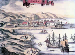 It fell to the Romans in 69BC after a fierce struggle but thrived afterward. Kastelli-the hillside area-was the site of the acropolis. Roman mosaics have been found under the modern marketplace in the city below, which was a the seat of a bishop during Byzantine times. The Genoese took the city from the Venetians during the 13th century and later the Venetians took it back, renamed it La Canea, and fortified it with strong western walls during the 14th and 16th centuries (the second time against pirate attack). The city fell to the Turks after a two-month siege in 1645, despite the Cretans having inflicted terrific losses on the Turks (to the tune of 40,000 dead), and became the Turkish capital of Crete and seat of the pasha. It was the first important Cretan center to surrender to Ottoman rule. Christian churches were converted to mosques (as they were everywhere in Greece after the Turkish conquest).
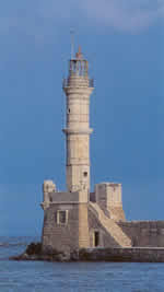
 One of the most visible landmarks of Hania's Outer Harbor (not the ferry harbor, which is at Souda Bay, 10km to the east) is the Mosque of the Janissaries with its large dome, built in 1645, when Hania fell to the Ottoman Turks. Unfortunately, when the mosque was restored, concrete was used for the dome. Near it is the local handicraft cooperative (open Mon0Sat 9:30am-10:30pm). It is this harbor which is one of the most photographed places in Greece (looking on it from the sea), with its Venetian and Turkish houses in the background, and the waterfront lined with tavernas, shops and stalls.
  Outside are the old fortifications, from which great views are to be enjoyed. In 1913, when Crete finally threw off the Ottoman yoke, the Greek flag was first raised here. This area is known as the Firkas. Check to see if they are still presenting Greek traditional dancing (in costumes) on Monday and Thursday evenings.
 From Platia Sindrivani (Fountain Square), you can follow Halidon south (away from the sea) up into the rest of the old city, and you'll soon come upon the Archaeological Museum (left) (open Tues-Sun 8:30am-3pm;2euros) housed in what was the Venetian church of San Francesco, once a very sumptuous affair. Later it was a mosque, with the base of the minaret and fountain remaining outside in the courtyard, as well as sculptures and decorative fragments from buildings. The museum exhibits include: Minoan pithoi (large clay storage pots), Minoan larnakes (clay tombs), tablets from Kastelli with inscriptions in Linear A and B scripts.,classical sculpture (right), Greco-Roman glassware, Roman mosaics.
 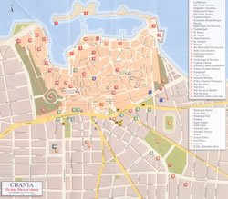 The area called Spiantza in the northeastern part of Hania, is one of the appealing neighborhoods in the city, with carved wooden balconies, restored kalderimia (cobbled streets), churches and minarets. The church of Aghios Nikolaos in Platia 1821, includes a minaret (albeit missing its top) in its structure, having gone through several lives from Venetian church to mosque and back to church again. The date for which the platia is named, though also the year that the Greek War of Independence began in the Peloponisos (Pelopponese), has to do with a large rebellion against Turkish rule and the hanging of an Orthodox bishop afterward. Two other interesting churches are San Rocco and Ayii Anargyri , the latter housing some ancient icons. (Click to see larger version of map right)
  The Inner Harbor has had some face-lifts in recent years and has become attractive to visitors. Two of the 16th century Venetian arsenals here have been restored, and parts of the old bastions remain. The boats moored here-fishing boats and yachts-- give a pleasant ambience to this part of town.
 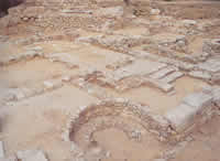 Kastelli is the oldest part of the town, up on the hills above the mosque. The name is the Venetian variant of castle, and castles on hills of seaside towns protecting the town from invasion from the sea. Kastelli was also the old town center during both Venetian and Turkish times, of which little remained after the bombardments during World War II. An excavation of a Minoan house was carried out near the street called 'Lithinon', and farther up the hill a second and larger excavation
 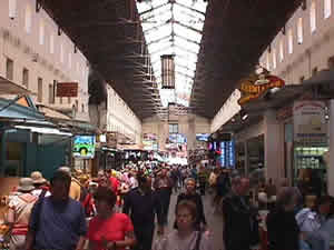 labeled, 'Minoan Kydonia' (right). Remains of a building found here point to destruction by fire during the same period of the destruction of Knossos -c.1450BC as well as clay tablets with the Linear A script used by the Minoans and traces of the old city walls. Neither site is open to the public, but you can look through the fence.
  Modern Hania surrounds the older city in every direction (except the sea). The Public Gardens lie southeast of the Market (left) and have a small zoo, with kri-kri (the indigenous small wild goat that still survives in the White Mountains), ponies, monkeys and birds). There's also a children's area, a cafι, and an auditorium which is also used for various events and cinema. The gardens were laid out by a 19th century Turkish pasha. The Historical Museum and Archives (Mon-Fri 9am-1pm;free) doesn't present much of interetst, and is in general a rather drab place.
  One place in Hania that isn't mentioned in guide books about Hania, is the Cafι Harhali, a kafeneio run by a syllogos (basically 'association', of which there are many in Greece dedicated to preserving and fostering traditional culture and music). This cafι is a gem of a hangout for some of the seasoned veterans of the older, authentic world of Cretan music. Though the place is rather barebones, resembling so many kafeneia all over Greece, and on a shabby back street, the difference is in the incredible collection of framed vintage photos on the walls- photos of musicians from decades of Hania's rich ethnic musical history. On one wall hand several instruments, ready to be played by musicians who wander in for a coffee, tsipouro or Raki . These include violi (violin), Cretan lyra) (upright held bowed instrument played with the fingernails) and the 'kafetzis' (who runs the kafeneio) is one of the veteran players of Cretan music on violin (which usually isn't associated with Crete, since the post-war years brought the lyra into greater prominence). Sometimes he gives lessons right there, and sometimes he plays too, with
  Cretan laouto (the larger, bass form of the Greek lute which played in Crete). Cafι Harhalis is named for one of the old fiddlers of Hania province, which is found at Grigoriou E 26, about a twenty-minute walk from the harbor. You probably won't find any English-speakers there, but if genuinely interested in the music of Crete, you'll likely be treated kindly. The kafetzis keeps some cassettes for sale in a drawer, though not all of them are the best to be found in Crete, though you might hit on a great one, since syllogi (plural of syllogos) produce local music with the aim of cultural preservation rather than commercial appeal. The down side of this, however, can be recordings of players whose value is more towards the cultural preservation end than towards the musical.
 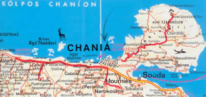 Akrotiri - Bay of Souda Looking at the map, Akrotiri peninsula appears like a round piece of land jutting up into the Cretan Sea immediately to the northeast of the city of Hania, with the large Souda Bay to its south above the point of land that defines the much larger Ormos Almirou (Salty Bay) to the east along Crete's north coast.
 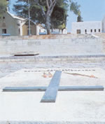 On the isthmus of land that leads uphill to the circular mass of Acrotiri are the Venizelos graves, (right) those of Cretan statesman, Eleftherios Venizelos (Greek prime minister in 1910) and his son Sophocles, who had asked to be buried here. Before the graves you'll find the chapel of Profitis Ilias (Prophet Elijah), which is a memorial to the much-loved statesman and huge figure in both Cretan and Greek modern history.
  Straight from here is the airport , with the northern road (left fork) heading towards the beaches, with nice country and some well-to-do villages and country homes inbetween. Though you pass Kalathas first, its beach is rather small. A little further on is the quiet beach of Torsanas (though there are summer houses there, so you will not, most likely, be all alone there).. Continuing towards the monastery of Aghia Triadha is Stavros (which means crossroads), a large sandy beach in a lovely circular bay fringed by cliffs on one side, with a cave that was an ancient sanctuary. A wonderful place to swim, and accessible by bus from Hania, with tavernas and rooms. The beach scenes from the movie Zorba the Greek were filmed here.
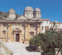 The monastery of Aghia Triadha (open daily 9am-7pm; 1.50 euros) (left) has an enormous cruciform church with several domes and Doric columns. It was founded during the 17th century and is also called 'Moni Zangarolo' after its founders, who were Venetian converts to Orthodox Christianity. Both church and monastery are built of pink and ochre-colored stone.
  Farther on, on a dirt-road that eventually turns to pavement is the second, older Venetian monastery of Gouverneto (open 7am-2pm;4-8pm; free) (right) with a small museum. This monastery is in the far northeastern corner of the peninsula, which is wild, rocky, rugged country, and dates to around the 11th century, and is yet another example of the siting of structures up high and away from the coast and potential pirate attacks (which were devasting Crete during this period). It forms a quadrangle with towers at the corners, and has an elaborately-decorated fascade and relief carvings on columns at the base and some frescoes inside.
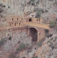 From here it takes about forty minutes to walk to the Monastery of Katholiko (left), an even older place, sited in a ravine amid cliffs. The monks here fled three centuries ago to Gouverneto after repeated pirate attacks. There are caves here, used during early Christian times, one of them with a chapel at its entrance, in pre-Christian times sacred to Artemis, who was worshipped here in the form of a bear.
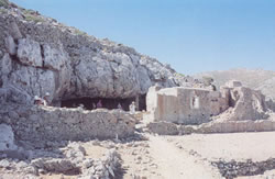 Interestingly, the later Christian chapel was dedicated to the Panaghia Arkoudhiotissa (right) (bear in Greek is 'arkhoudha'), illustrating the often unbroken line in Greece between pre-Christian places of worship later converted to Christian ones and renamed. You pass this cave on the way to Katholiko, whose buildings lie on either side of a bridge above a dry stream-bed. There is a vigil held here on the eve of St John's Feast Day, on 7 October, St John's grave found in a cave near the bridge. This saint was called 'Ermitis' (hermit), who was a 11th century evangelist. After the Byzantines had taken Crete back from the Saracens, it was he, whose life's work was the re-establishment of Christianity. At the bottom of the ravine (which you can get down to, though there is no path), you can follow the streambed to the sea, where there is a a tiny cove and the remains of a port. The water there is lovely, though you have to swim from the rocks, there being no beach.
 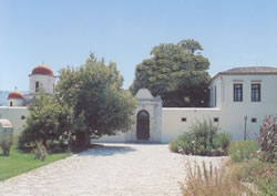 The south side of Akrotiri is dominated by the military presence, and the beaches at Sternes (which are not very accessible). West of Souda, towards Hania on a short side road, is the Moni Chrissopighi (left) (open 8am-12noon; 3:30pm-6pm), with a church and museum with icons from the 15th century on.
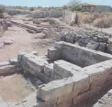 Aptera The old Turkish stone fortress of Idzeddin east of Souda on steep Cape Kalami is now the Hania prison. Beyond here on a plateau is the site of ancient Aptera, (left) dated to the 11th century with 4km of massive walls; a Classical temple here (whose foundations remain),, as well as a theatre and a later Roman basilika., , as well as a monastery later built on top of huge Roman cisterns. It was a leading Cretan city in early Christian times. Unfortunately, you don't get to see much of it behind the fences.. At the top of the hill, though, from the remains of a Turkish fort (Koules pic below right) above the
  Izeddin fortress/prison, there are great views of Souda Bay, including the three small islands in the bay, which include Nea Souda bristling with military installations.
 Inland a little ways is Stylos with its Minoan tomb (left). Stylos is the location of the last Allied stand made by the Australian and British during the Battle of Crete,their presence allowing most of the Allied troops to flee south along what was then the main road towards the Imvros gorge and Hora Sfakion, meanwhile becoming stranded themselves and seeking refuge in the nearby villages (some of which were destroyed in German reprisals for this). The detour towards Samonas is worth the difficult road for the church of Aghios Nikolaos at Kiriakoselia, with its incredible 13th century frescoes. You have to go to Samonas and find the guardians of the key, though. Ask around there.
 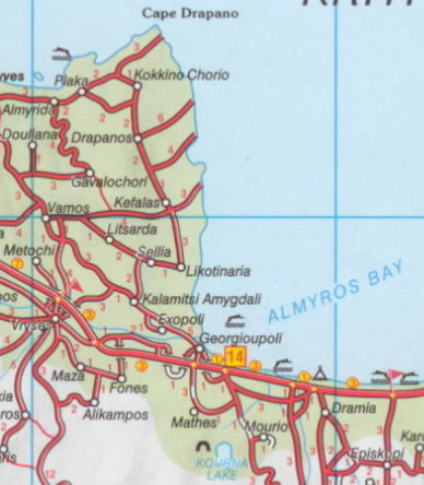 Cape Drapano is another place where parts of the filming of Zorba the Greek were done (at Kokkino Hora), (to the west of which is Plaka, a very pretty village with beaches below it). A really beautiful peninsula with rich green agricultural land of vineyards, olives and cypresses, prosperous villages (and good roads).
  Yeorghioupolis (right) is just east of the bottom of the peninsula at the mouth of the Almyros River (Salty River) and close to the westernmost coastal boundary of Rethymno province. This is a lush place with eucalyptus trees in the big square, a little quay and fishing boats, a long beach, some springs at the east end of the little harbor, and small streams that flow into the sea with little wooden bridges across them. A breakwater protects swimmers from the currents that are a danger farther away. To the north of the river is another small sheltered bay, and beyond there some caves and a chapel. This place has become a resort, with many rooms and tavernas , which fill up in high season.
 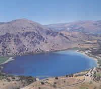 Lake Kournas (pic left, see map above) inland 4km from Yeorghioupolis is Crete's only freshwater lake - a shallow lake surrounded by hills and covering 160acres. This place is, well worth the walk there due to its changing colors (depending on time of day and the position of the sun).
 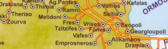 Back towards the west (inland) is the town of Vrysses (which means 'springs' or 'taps') on the main road south of Kalami, but is also at the junction of the old road and for the road to the south. This town sits on the banks of the Almyros River from Hania, was the hometown of Venizelos' mother, and it was here that the 1905 Revolutionary Assembly was held that led to Crete's finally becoming part of Greece in 1913. The Theriso gorge is near here. There's good hiking both in this lesser gorge though, with it's pretty spots, and in general around this area. You can hike to Meskla from Theriso, a rough walk but not unenjoyable.
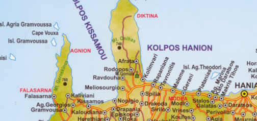 The coast west of the city has seen commercial and rather tacky tourist development all the way from Kato Stalos to Platanias, though it thins out after there. The road stays pretty close to the sea all the way to the Rodhopou Peninsula, and, while there are beaches, there is also wind and rough seas, and the water is not so clean.
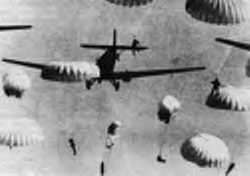 Crete's defeat by the Germans during the horrific Battle of Crete in 1941 has been attributed to the loss of the crucial airfield at Maleme by the Allied forces stationed on this part of the northern Cretan coast. Inability to defend this airfield gave the Germans the advantage, (though they had at first suffered terrible losses when their airborne divisions of parachutists and gliders were almost totally wiped out).
 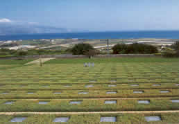 During the evacuation Cretan resistance fighters aided the foreign troops, often risking their own lives (see above about the Allied cemetery near Souda Bay), and many Cretan villages suffered reprisals for having hidden either Cretan or foreign fighters (something which happened throughout the war, all over Greece, with an estimated thousand villages burned by Hitler's armies). Needless to say, the Cretan resistance was just getting started with this defeat and the beginning of German occupation of Crete, the Cretan guerillas aided by Allied undercover agents and supplied from North Africa. A well-researched book,about the battle, which includes many first-hand accounts is Crete: The Battle and the Resistance by Anthony Beevor; The Cretan Runner, by Yiorghios Psychoudakis, is another. Present-day Maleme is a military zone, and hence restricted. Before the airfield is the German war cemetery (photo above), where all of the parachutists who were shot before they reached the ground (and those in crashed gliders) are buried. Very ironically, there was a Late Minoan Tomb discovered here in 1966, dated back three millennia, reachable by a downhill path from the modern cemetery.
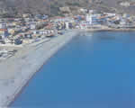 Tavronitis is a farming village, with pontoon bridges from the war and is the junction with the road to Paleohora.on the south coast.
 The Rhodopou Peninsula is wonderful hiking country, though you can drive the short distance to Afrata, on a paved road which then becomes dirt. Near the first short stretch is the 17th century monastery Moni Gonia, (right) which sits up over the sea. (Open in summer Mon-Fri and Sun 8am-12:30pm/4-8pm; Sat 4-8pm;winter daily 3:30-5:30pm;free, no shorts allowed) Turkish cannonballs are still visible, stuck in the walls, and there are post-Byzantine icons.
 The Imvros gorge The road climbs from the village of Imvros up along forested slopes over the gorge itself, to descend finally and dramatically to Hora Sfakion, with stunning views of the south coast and Libyan Sea. The endless hairpin turns are, needless to say, to be driven with extreme vigilance, especially as the road is narrow and there are buses often coming from the other direction.
  The word 'hora' is used all over Greece to denote the main town in an area, as this town is to the 'eparchy' (administrative district within a prefecture) of Sfakia. During the evacuation of the Allied Forces here, some 18,000 men passed through here on the way to their liberty, (escaping the fate of some 12,000 who were taken prisoner and the approximate 2000 killed). As noted earlier, the Cretan villagers who helped them were dealt with cruelly afterward, many of them executed, as a memorial here commemorates, with the skulls on display.
 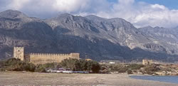 Frangokastello to the east of Hora Sfakion along the main coast road is one of the nicer places by the sea in Crete, with good sandy beaches and clear beautiful water, both near the castle and farther to the east as well. There are many streams coming out along the coast here, including one just below the castle with ducks on it, and more to the west . Camping on the beaches (and in the dunes) along the coast here, is a definite option.
  The Omalos Plateau (right) is at 1100 meters, surrounded by the highest peaks of the Levka Ori (White Mountains) with passes leaving from three corners (the plateau being triangular in shape). The unsuccessful Cretan revolt against the Turks of 1866-7 began here, and the grave of one of Crete's great rebel leaders Hatzimihalis Yiannaris is here next to his house and a chapel, who became president of the Cretan Assembly which won union with Greece in 1912 after nearly a century of bloody struggle. He had the chapel built and dedicated to the saint to whom he had prayed while languishing in a Turkish prison.
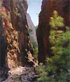 Further west is the start of the trail to the Samaria gorge, the head of the gorge being at the pass of Xyloskalo at 1227meters, where there's a cafι to stop before embarking on the hike down. The trek from Omalos plateau to Aghia Roumeli is 17 or 18 km (depending on whom you listen to) and is made by thousands every year. Despite the supervision of rangers and the crowds that will accompany you on this popular trek, it is advised that you do not attempt it if not basically fit and an experienced hiker (or at least used to long walks), and that you wear very sturdy shoes with soles that can withstand sharp rocks). Prepare yourself as well for exposure to hot sun. From the head of the gorge you can also hike to Mt. Gingilos (2080meters), which takes about two or three hours to the top, and is very steep. Stick to the path to avoid trouble. A good friend of mine had a heart attack in the gorge and passed away.
  Loutro east of Aghia Roumeli, Loutro is one of the most serene places on Crete's south coast, with swimming from the rocks around a small bay. Though certainly a tourist destination, it is reachable only on foot and by boat, which has no doubt succeeded in keeping it from the fate of so many other seaside places in Crete (and elsewhere). Though there is no real beach here (and, at least in previous years, some taboos against topless bathing for women, there are secluded beaches to the east reachable both by hired canoe and by the coastal trail that goes all the way to Hora Sfakion (an E-4 European footpath).You can also hike up to the mountain village of Anopoli (see previous section on Hora Sfakion). There are tavernas and rooms in Loutro, and camping out is possible, but more accepted at some distance on the eastern beaches and coves such as Sweetwater to the east, and Marmara to the west.
 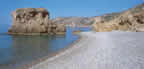 For centuries this was the fishing village and port for the village of Koustoyerako (and in ancient times for the ancient city of Elyros), Its old name (Syia) meant 'pig town' and the region was covered in oak forests. But good roads have brought the inevitable tourists, especially as the beach here (left) is one of the best on Crete's south coast and the surrounding countryside offers good hiking opportunities. The pebble beach is on a nice bay with very clear water and some tamarisk trees which people camp under. Around the east end of the bay people dispense with bathing suits and the spot has been dubbed "The Bay of Pigs'. There are many rooms, plenty of them in the lowest price category, the best at the entrance to the gorge. The village itself has a rather thrown-together look, with half-built structures (something not unusual in Greece).
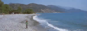 Paleohora, spans two beaches one stony and one wide and sandy, the latter with tamarisk trees that are sometimes camped under, and good windsurfing. There is also an official campsite. Called Castello Selino by the Venetians, for the castle built on the tip of the peninsula in 1279, more for local control than protection against invasion from the sea, but captured and destroyed by the notorious pirate, Barbarossa in 1539. This village stays warm in winter, and probably a nicer place to be then, as it has become increasingly crowded in summer, with the tavernas and bars on the main avenue overflowing in the evenings. On the positive side, it seemed to be geared towards the cheaper end of things. Some foreigners now live here year round. There's a new marina that now dominates the point where the castle is, though there isn't much left of it besides some broken walls.
  The mountain villages around here have kept their simplicity and traditional character, notably Anidri to the northeast, with a frescoed 14th century church. Towards Soughia, on a pretty rough road (8km) is Azogyres, a very green place with a stream and a small historical museum (open Sat and Sun 9am-2pm) which is quite interesting and which deals with the period of the Turkish occupation. .At the bottom of this village, next to the chapel of Aghios Pateres is a very rare evergreen plane tree, and the chapel has a carved iconostasis which is the work of a local craftsman. Above this village is the cave of Soure said to have been temporarily occupied by the 'Holy Fathers' (pateres) who had returned from Egypt after the return to Byzantine rule in Crete. There is a metal stairway and rock steps descending into the cave. Taking a flashlight/torch is a good idea if you want to go any distance, though.
  Falasarna lies below the Gramvousa Peninsula which juts up from northwesternmost Crete to enclose the Kisamos Gulf on the west. The ancient city and port lie to the north of the beach. It was the westernmost city-state of Crete, at its peak during the 4th to 3rd centuries BC, though evidence has been found of occupation dating to the 6th century BC. For a time it was the port for Polyrrhenia on the west coast but the two towns were also enemies. An enclosed harbor mentioned by ancient geographers could not be found during the 19th century during a Royal Navy survey. Later excavations revealed that there had been late 5th century AD tectonic displacement altering the sea level, raising the coast 6-9meters above its present level. The acropolis was on Cape Koutri. A fort was built by the Venetians on the tip of the peninsula in 1579, that held out till 1692 against the Ottoman Turks, 23 years past the surrender of Iraklion. Later Gramvousa became a pirate stronghold. You can walk out to the cape in about two or three hours and visit the white sand beach at Tigani Bay (Frying Pan Bay).
 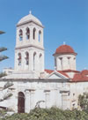 Sfinari is a small village inland from a pebble beach, and has a few rooms. Kambos (plain) is further down along a wooded stream, with more rooms and a kalderimi leading towards Sirikari. This region is cooler than the rest of Crete with wildflowers here later in spring by a good two weeks. There are dirt roads to the coast here and there. Kefali (which means 'head') is a very nice village high up above a wooded valley, with tavernas and rooms. There's a frescoed church here, Metamorfosis tou Sotirou (Transfiguration of the Savior), with early 14th century frescoes and a dirt road to a monastery on the coast (11km) Moni Hrysoskalitissa (right) on the coast, with more churches on the way at Vathi. There are many chesnut trees in this area , an important crop in this region, which is also well-watered, with a stream along the road as you continue south towards the bay of Stomio. The blue-roofed monastery, now a convent inhabited by a few nuns, was built in a grotto, its church dedicated to the Panaghia Hrysoskalitissa (Virgin of the Golden Stair), and one must descend ninety stairs to the cove below the rock on which the church was built. Great views are to be enjoyed from the top. Shards found here point to the existence of a Minoan settlement on this site.
 Unfortunately there is also a gypsum quarry at Stomio and too many concrete buildings to make the place a bit undesirable for those seeking seaside places with 'atmosphere'.
 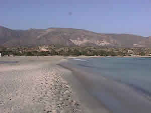 Between Topolia and Vathi (to the southwest) you travel through some of the most fertile countryside in Crete, with woods and mountain streams, flora and fauna, Elos and Kefali with a tremendous abundance of water, such that agriculture is preeminent and tourism dispensable. Near the village of Voulgharo, in Makronas and Mouri are the churches Aghios Yiorgos and Ayhios Nikolaos, and there are more frescoes in the church of Aghia Paraskevi in Topolia.
 ©2024 Real Estate in Greece.net | Contact | | Bookmark Sitemap |

