 |
Rethymno Crete

This prefecture offers some
lovely countryside with good hiking, interesting villages, as well as the attractions of the city of Rethymno itself; and on
the south coast both wildness and some fine beaches can be found, in varying combinations of the two. There are also
ancient cities and monasteries, some of which are described below.
Rethymno Prefecture ('nomos' in Greek) is the smallest of Crete's four prefectures in both size and population, with the
city of Rethymno Crete's third largest city (after Iraklion and Hania) as well as provincial capital , situated on the
north coast of Crete 78km/48.5miles to the west of Iraklion and 58km/36miles to the east of Hania. Rethymno prefecture
is bounded by the Psiloritis mountain range on the east and the Lefka Ori (White Mountains) on the west and its north-south
distance is one of the narrowest in Crete. The northern coast of this province dips south lower than the provinces to east
and west, and though the part of the Aegean Sea north of Crete is generally known as the Kritiko Pelagos (Cretan Sea),
the gulf between the city of Rethymno and the higher part of the coast to the west is known as the Ormos Almirou (Bay of
Salt, literally) and the province is bounded in the south by the Liviko Pelagos (Libyan Sea).
Cretan Folk Music Center
 Rethymno (both city and province) was a very important center of Cretan folk music, with some of its vintage recordings
from 1920-1955, as well as others from Hania province and city, memorialized in a fabulous collection entitled Protomastores
(''first/best masters', roughly). Although the collection has been reissued on CDs, it originally comprised a box of ten
cassettes, accompanied by a book with text about the musicians (with adjacent English translations), photos, and song lyrics
(in Greek), as well as an introduction with photos and text about the instruments and drawings illustrating Cretan dance
(with English translation). Anyone interested in authentic Cretan folk music should ask for this collection in music stores.
You won't get the book, though, with the CD collection. Rethymno (both city and province) was a very important center of Cretan folk music, with some of its vintage recordings
from 1920-1955, as well as others from Hania province and city, memorialized in a fabulous collection entitled Protomastores
(''first/best masters', roughly). Although the collection has been reissued on CDs, it originally comprised a box of ten
cassettes, accompanied by a book with text about the musicians (with adjacent English translations), photos, and song lyrics
(in Greek), as well as an introduction with photos and text about the instruments and drawings illustrating Cretan dance
(with English translation). Anyone interested in authentic Cretan folk music should ask for this collection in music stores.
You won't get the book, though, with the CD collection.
 Rethymno Town Rethymno Town
The city of Rethymno (population approximately 25,000), despite the increase in tourists during the past 25 years, is
still a more provincial and slower-moving place than either of the two big cities in both directions. A long sandy beach
flanks the town, with the walls of a massive Venetian fort at one end up above it on the hill, and below it the old
Venetian harbor and a lighthouse. The old parts of town are graced with both Venetian and Turkish buildings, the latter
with over-hanging wooden balconies with iron supports, though sometimes it's hard to tell which is which, as generations
have restored and added on to the buildings. There are mosques, and Turkish fountains. The University of Crete has some of
its departments in Rethymno, bringing students from all over Greece to the city, along with the usual ambience of university
towns.
Historically
 
Historically, Rethymno was first a Minoan settlement which was situated east of the fortress, and later the ancient
autonomous city of Rithymna; later a small Roman town; and during the 9th and 10th centuries and Arab one. Its history
during Byzantine times is largely unknown, It fell to the Venetians during the 13th century. The town center during those
times was closer to the shore, including the old Venetian and Turkish districts near what is called the Inner Harbor.
There were many Greek converts to Islam during Ottoman rule (something that happened in all Crete) though they continued
intermarrying with Christians, drinking wine, and speaking Greek. The population of Rethymno by the 19th century was mostly
Muslim, but in 1923 most of them were evicted to the new nation of Turkey during the compulsory exchange of Muslims and
Christians that followed the disastrous Greco-Turkish conflict. 'Chronicle of a City', by Cretan author Prevelakis, deals
with this traumatic event.
Venetian Fortress "The Forteza"
 The Venetian Fortress (also called 'Forteza' and 'Palaiokastro'), is allegedly the biggest castle built by the Venetians anywhere in Greece,
costing a fortune and taking ten years to build with forced labor imported from several islands, all this in response to
repeated pirate raids during the middle of the 16th century. The notorious Turkish pirate, Barbarossa was one of the assaulters of
the town. Nevertheless, the city fell (in 1645) to the Ottomans in one day, the Turks just going around the fort to take the
city. The fortress itself held out between 23 days and two months, depending on whom you believe. There had been prior
fears that without a moat around it, it would not keep invaders out, though still it seems that it offered little
protection to the town itself. The Venetian Fortress (also called 'Forteza' and 'Palaiokastro'), is allegedly the biggest castle built by the Venetians anywhere in Greece,
costing a fortune and taking ten years to build with forced labor imported from several islands, all this in response to
repeated pirate raids during the middle of the 16th century. The notorious Turkish pirate, Barbarossa was one of the assaulters of
the town. Nevertheless, the city fell (in 1645) to the Ottomans in one day, the Turks just going around the fort to take the
city. The fortress itself held out between 23 days and two months, depending on whom you believe. There had been prior
fears that without a moat around it, it would not keep invaders out, though still it seems that it offered little
protection to the town itself.
The entrance to the fortress is across from the Archaeological Museum, on the southeast corner (not on the waterfront).
Besides the cafι, there is a deep well off to the left with a downward sloping passageway leading to it. ' In the center,
past remains of arsenals, officers' houses and the like, is a large domed structure (first a church and then the Ibrahim Han mosque), which
was built as a refuge for the entire town population. in the event of an attack.
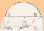  The domed Ibrahim Han mosque (left) has a carved prayer niche (known as a
mihrab) pointing the direction of Mecca, though this has been vandalized. The cisterns where rain-water was collected are
marvelous, with light coming through slits on the sides. Standing up on the fortress walls and looking out at the town
and harbor, as well as the coast to the west, is a fine pastime while visiting Rethymno. (Open Sat-Thurs
8:30am-7pm;Nov-March closes 6pm;2.90euros). In August and September there is a twenty-day Renaissance Festival held
here. The domed Ibrahim Han mosque (left) has a carved prayer niche (known as a
mihrab) pointing the direction of Mecca, though this has been vandalized. The cisterns where rain-water was collected are
marvelous, with light coming through slits on the sides. Standing up on the fortress walls and looking out at the town
and harbor, as well as the coast to the west, is a fine pastime while visiting Rethymno. (Open Sat-Thurs
8:30am-7pm;Nov-March closes 6pm;2.90euros). In August and September there is a twenty-day Renaissance Festival held
here.
The Town Beach: A breakwater keeps the sea calm for swimming, and there are cafes and showers, but you must expect crowds
in summer. Better beaches to the east (beyond the harbor) which go on for miles, still crowded, but with cleaner water.
You'll find all the rest along the way as you walk along the beaches, restaurants, bars, travel agents, hotels, etc.
  Archaeological Museum (open Tues-Sun 8:30am-3pm;3euros). Across from the fortress, this structure was built by the Turks
as a bastion,and later used as a prison. The museum was rehoused here in 1990. A beautiful building with Neolithic finds from the Yerani caves (right), with clay and stone idols, tools of bone and obsidian; one of the most inclusive collections from that period in
any Cretan museum; finds from the Protopalatial settlement at Monasteraki in the Amari valley, which was excavated by the
University of Crete. Figurines from the peak sanctuary of Mount Vrysinas above Rethymno: votive offerings, mostly of
worshippers and cattle, and Linear A script on a stone vase. More finds from various tombs; Mycenaean period idols; finds
from excavations at Eleftherna in the foothills of Mt. Psiloritis/Mt. Ida. Artifacts from later periods: Archaic, Classical,
Hellenistic, and Roman. Archaeological Museum (open Tues-Sun 8:30am-3pm;3euros). Across from the fortress, this structure was built by the Turks
as a bastion,and later used as a prison. The museum was rehoused here in 1990. A beautiful building with Neolithic finds from the Yerani caves (right), with clay and stone idols, tools of bone and obsidian; one of the most inclusive collections from that period in
any Cretan museum; finds from the Protopalatial settlement at Monasteraki in the Amari valley, which was excavated by the
University of Crete. Figurines from the peak sanctuary of Mount Vrysinas above Rethymno: votive offerings, mostly of
worshippers and cattle, and Linear A script on a stone vase. More finds from various tombs; Mycenaean period idols; finds
from excavations at Eleftherna in the foothills of Mt. Psiloritis/Mt. Ida. Artifacts from later periods: Archaic, Classical,
Hellenistic, and Roman.
 Historical and Folk Art Museum (open Mon-Sat 9am-2pm and 6-8pm; 3euros). On Mesolongiou St. A very interesting museum
with weaving , embroidery, lace. traditional costumes, knives, pottery wooden chests, musical instruments, farm implements,
smith's tools, a guide to bread-making techniques, basketry, photos. Accounts of how many of the objects were found. An
impressive display that illustrate the old ways that people lived for centuries in Crete up until a few decades ago. Historical and Folk Art Museum (open Mon-Sat 9am-2pm and 6-8pm; 3euros). On Mesolongiou St. A very interesting museum
with weaving , embroidery, lace. traditional costumes, knives, pottery wooden chests, musical instruments, farm implements,
smith's tools, a guide to bread-making techniques, basketry, photos. Accounts of how many of the objects were found. An
impressive display that illustrate the old ways that people lived for centuries in Crete up until a few decades ago.
The Guora Gate (Porta Guora), near the Platia of the Four Martyrs, is all that remains of the old walls that were meant to
fortify the town after attacks by both pirates and Turks during the 16th century. It was the entrance to the old Lower
Town which was near the Inner Harbor (below right) (at the northeast end of the present city) and had three bastions, with soldiers'
quarters built next to one of them, some of which have survived (at Odos Ethnarchou Makariou and Leoforos Kountourioti.
Though this was the main gate, there were two others. Very close by you can see a minaret and and old sundial.
 Just south of here are the Public Gardens which were laid out during the Ottoman period, near the Turkish cemetery. The
Rethymno Wine Festival is held here during the last days of July as well as a Handcrafts Exhibit.. These gardens were
converted in 1923 from what had been the Turkish cemetery adjacent to the Sultana's mosque (dedicated to the Sultan's
mother) just outside the Guora Gate. Just south of here are the Public Gardens which were laid out during the Ottoman period, near the Turkish cemetery. The
Rethymno Wine Festival is held here during the last days of July as well as a Handcrafts Exhibit.. These gardens were
converted in 1923 from what had been the Turkish cemetery adjacent to the Sultana's mosque (dedicated to the Sultan's
mother) just outside the Guora Gate.
On Wednesdays, there is a weekly market/fair off of Odos Kanzantzaki.
  The Rimondi Fountain (left and right) One of the 'markers' for the part of the city of Rethymno most attractive to visitors, the other
being the Venetian Loggia (below right),
both are on Paleologou, at opposite ends. The Rimondi Fountain (left and right) One of the 'markers' for the part of the city of Rethymno most attractive to visitors, the other
being the Venetian Loggia (below right),
both are on Paleologou, at opposite ends.
The fountain's water flows from lion head taps into a marble basin , (resembling
the fountain in the town of Spili, below) and was built by J. Rimondi, the Rector, in 1626, on the site of a previous
fountain. There are Corinthian half-columns and a decorated cornice. One of two columns remains that supported the old dome
that covered the bowl. This is the best known of several fountains scattered throughout the town.
  Built during the 16th century, the Venetian Loggia was used for official meetings and also for social gatherings and
gambling. It has remained very intact, with its three arches on each of its sides, one for the entrance, and the others
windows, and inside are pillars with Ionic capitals used to hold up the roof. Under the Ottomans it was a mosque, and
later it housed the Archaeological Museum before it moved to its present location, where there is now a shop with
reproductions of Classical art. Built during the 16th century, the Venetian Loggia was used for official meetings and also for social gatherings and
gambling. It has remained very intact, with its three arches on each of its sides, one for the entrance, and the others
windows, and inside are pillars with Ionic capitals used to hold up the roof. Under the Ottomans it was a mosque, and
later it housed the Archaeological Museum before it moved to its present location, where there is now a shop with
reproductions of Classical art.
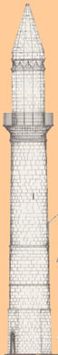
 There are five mosques in Rethymno, the most famous of them, the Nerandzes (left) , which is also the best preserved. When
converted to a mosque in the 17th century, it was given three domes, and a minaret was added in 1890. There are five mosques in Rethymno, the most famous of them, the Nerandzes (left) , which is also the best preserved. When
converted to a mosque in the 17th century, it was given three domes, and a minaret was added in 1890.
It once housed a music
school and later a concert hall. There is also an old Turkish School and a Hamam (Turkish Bath). Ayios Frangiskos (St. Francis) ( above left) is a large church with sculpture on the frames of the doors and a wooden-beamed basilica. There are three large churches besides this one: Syria ton Angelon, Ayhios Andonios, and the Cathedral.
Interesting Sights in Rethymno Province
 Just east of the city is the road that goes to the very pretty Prasano gorge, the trail just past Prassies (south of
Ptatania on the coast), which is accessible by bus.. Prasano (which means green) is a gorge formed by the Platanias River
(platani/platanos meaning plane tree) which is dries up between mid-June and mid-October, and is flanked by olive and cypress
trees, as well as the plane. The trail ends up on the coast near Misiria. Just east of the city is the road that goes to the very pretty Prasano gorge, the trail just past Prassies (south of
Ptatania on the coast), which is accessible by bus.. Prasano (which means green) is a gorge formed by the Platanias River
(platani/platanos meaning plane tree) which is dries up between mid-June and mid-October, and is flanked by olive and cypress
trees, as well as the plane. The trail ends up on the coast near Misiria.
The Monastery of Arkadhi
 The Monastery of Arkadhi (Moni Arkadiou) (open daily 8am-8pm;2 euros) is 25km/15.5miles southeast of the city in the
Psiloritis foothills, with nice scenery along the way if you are driving on the old road. In 1866, during the long Greek War
for Independence (with Crete liberated only in 1913), freedom fighters and their families (300 armed men and 600 women and
children) under the leadership of the Abbot Gabriel, took refuge inside and blew up the gunpowder magazine and themselves
with it after a two-day battle with the 15,000 besieging Turks, just at the point of defeat when the Turks began
entering the fortress-like monastery. Needless to say, both Greek and Turk died in the explosion. This horrific event
marshaled international support for the long and bloody struggle in Greece against Ottoman rule. The munitions storeroom
remains vault less to this day, and the monument outside of the entrance presents skulls of some of the victims with various
relics of -the event housed in a small museum. The Monastery of Arkadhi (Moni Arkadiou) (open daily 8am-8pm;2 euros) is 25km/15.5miles southeast of the city in the
Psiloritis foothills, with nice scenery along the way if you are driving on the old road. In 1866, during the long Greek War
for Independence (with Crete liberated only in 1913), freedom fighters and their families (300 armed men and 600 women and
children) under the leadership of the Abbot Gabriel, took refuge inside and blew up the gunpowder magazine and themselves
with it after a two-day battle with the 15,000 besieging Turks, just at the point of defeat when the Turks began
entering the fortress-like monastery. Needless to say, both Greek and Turk died in the explosion. This horrific event
marshaled international support for the long and bloody struggle in Greece against Ottoman rule. The munitions storeroom
remains vault less to this day, and the monument outside of the entrance presents skulls of some of the victims with various
relics of -the event housed in a small museum.  Every 7-9 November the anniversary of the blast is 'celebrated', (because,
no matter how terrible the event, it stood as a symbol of the struggle for independence, synopsized in the slogan, 'Freedom
or Death!') . Though the main gateway had to be rebuilt after the explosion, most of the monastery remains intact. Before
the explosion, it was one of Crete's richest monasteries, much visited by travelers. During World War II it gave support to
the resistance, as did others in Greece. Every 7-9 November the anniversary of the blast is 'celebrated', (because,
no matter how terrible the event, it stood as a symbol of the struggle for independence, synopsized in the slogan, 'Freedom
or Death!') . Though the main gateway had to be rebuilt after the explosion, most of the monastery remains intact. Before
the explosion, it was one of Crete's richest monasteries, much visited by travelers. During World War II it gave support to
the resistance, as did others in Greece.
The double-nave church survived, a gem among Venetian monuments, with its 16th century west facade (dedicated to The
Transfiguration of Christ and the Saints Constantine and Helen). The rest of the monastery is 17th century, though it was
founded as early as the 11th century. There are pairs of Corinthian columns in the colonnade. On the north side of the
courtyard you can see bullet holes in the old Old Refectory and the roofless gunpowder storeroom., but, counteracting all
this sadness, the views from the east gate and from the walls above, (the latter looking South towards Mt.
Psiloritis/Ida), are lovely.
 There is an ancient bridge below the monastery near the modern road from Rethymno. A dirt-road starting near the
Arkhadi cafι-and leads to the Viran Episkopi-Eleftherna road a pleasant walk of two hours. If you take the old road from
Rethymno via Adhele and Piyi, you can stop in Panormos (left) where there's a taverna with its own wine in different vintages
(Taverna Panorama) and lovely views over olive orchards. There is an ancient bridge below the monastery near the modern road from Rethymno. A dirt-road starting near the
Arkhadi cafι-and leads to the Viran Episkopi-Eleftherna road a pleasant walk of two hours. If you take the old road from
Rethymno via Adhele and Piyi, you can stop in Panormos (left) where there's a taverna with its own wine in different vintages
(Taverna Panorama) and lovely views over olive orchards.
 Eleftherna (right) was one of the main ancient cities in Crete. Built on a ridge in the foothills of the Psiloritis range above
two tributaries of the Mylopotamos River, it was the birthplace of the 4th to 5th century BC philosopher Diogenes, and
minted its own coins with depictions of Apollo and Artemis. Evidence of Minoan occupation has been found at Elefherna,
which was later one of the major Dorian city-states from the 10thcentury BC until medieval times, and fell to the Romans
during the 1st century BC but thrived under Roman rule as well. Major excavations were done here since 1984 by the
University of Crete (Archaeology and History Departments, based in Rethymno). The acropolis and defensive tower stand on
a high promontory between two streams with a narrow road (more of a cobbled path, of the kind known as a 'kalderimi')
leading to it, with the city on the slopes below and on the other side of the valley where the modern town is now situated.
There is a bridge spanning one of the streams reachable in a walk of about a half hour. Beyond the acropolis and the
little chapel of Aghia Irini are cisterns cut out of rock, which were supplied by an allegedly Roman aqueduct which
channeled water from nearby springs. Eleftherna (right) was one of the main ancient cities in Crete. Built on a ridge in the foothills of the Psiloritis range above
two tributaries of the Mylopotamos River, it was the birthplace of the 4th to 5th century BC philosopher Diogenes, and
minted its own coins with depictions of Apollo and Artemis. Evidence of Minoan occupation has been found at Elefherna,
which was later one of the major Dorian city-states from the 10thcentury BC until medieval times, and fell to the Romans
during the 1st century BC but thrived under Roman rule as well. Major excavations were done here since 1984 by the
University of Crete (Archaeology and History Departments, based in Rethymno). The acropolis and defensive tower stand on
a high promontory between two streams with a narrow road (more of a cobbled path, of the kind known as a 'kalderimi')
leading to it, with the city on the slopes below and on the other side of the valley where the modern town is now situated.
There is a bridge spanning one of the streams reachable in a walk of about a half hour. Beyond the acropolis and the
little chapel of Aghia Irini are cisterns cut out of rock, which were supplied by an allegedly Roman aqueduct which
channeled water from nearby springs.
A large structure from the Early Christian period was found on the site of a sanctuary from the Archaic and Hellenistic
periods not far below the summit of the promontory. An Early Iron Age cemetery was excavated on the valley floor (now
heavily farmed) below the acropolis, at a site where a later Roman road was built. Skeletons of children who had been buried
in pithoi (big clay urns) were found, as well as stone chambers with evidence of both burial and cremation practices.
Bodies were cremated on elaborate pyres, surrounded by jewelry, pottery, ivory work, weapons, personal possessions and the
fires were built to reach and stay at temperatures of 900 degrees Centigrade . After the pyres were quenched, the bones
were cleaned and stored in pithoi or amphorae. Strong evidence was found during the 1990s of human sacrifice carried
out here during the 8th century BC, and in front of the funeral pyres of persons of importance, correlating with Homeric
accounts of the sacrifices of Trojan prisoners in front of the funeral pyre of Achilles during the same period. The evidence
included a knife and whetstone found near the neck of the headless victim. Other finds on this site included gold, crystal,
bronze, glass, faience, pottery , and some beautifully carved ivory heads. An Archaic statue of a female torso was also
found which is housed in the Heraklion Archaeological Museum, as well as fragments of a limestone kouros (6th century). On
the east side of the acropolis hill are Byzantine finds from the 10th century, a domed church with frescoes from the 12th
century, the remains of a Roman villa, and an Early Christian basilica.
In the new town, Nea Eleftherna an open air sanctuary was found with terracotta figurines of animals and humans. Nearby Margarites has a long ceramic tradition, with pottery workshops and shops selling their work all over the
village.
Perama, to the north , takes its name from the fact of its being a crossing-place over the Mylopotamos River ('perama'
being a ford, 'mylo' a mill, and 'potamos' a river). There is evidence of there having been a Minoan sanctuary here (bronze
figurines), and it was later a Roman, Venetian, and Turkish settlement. In modern times it is mainly an agricultural town
with some light industry.
There's a large cave, near Melidhoni 5km/3.1miles from Perama, the walk taking about half an hour. In 1824, during the
independence struggle , three hundred villages suffocated after a Turkish commander set a fire at the entrance to the cave,
after having failed to suffocate them by blocking the entry with stones (the villagers having opened holes in the
barricade). A shrine at the entrance commemorates this horror, and inside, one finds stalactites and stalagmites instead of
bones.
 Axos was a large ancient city, first built in Minoan times and associated with many myths, and which had its port at
present day Bali (left). Axos was a large ancient city, first built in Minoan times and associated with many myths, and which had its port at
present day Bali (left).  It had an acropolis and massive walls, built later, and (like Elevtherna) minted its own coins, with
depictions of Zeus, Apollo and Artemis. There was a temple of Aphrodite there, as well as a 7th century temple, as well as
bronze shields and helmets which were votive objects, and beautiful churches from Byzantine and Venetian times, some
with good frescoes, Aghia Irini (right) is among them, and remains of the aqueduct. Axos was a guerilla center during the
independence struggle of the 19th century, and the town was burned by the Turks. The site is located on a hill above he
present-day town which has weaving and embroidery, for sale and tavernas much frequented by tourists. An appealing
town. It had an acropolis and massive walls, built later, and (like Elevtherna) minted its own coins, with
depictions of Zeus, Apollo and Artemis. There was a temple of Aphrodite there, as well as a 7th century temple, as well as
bronze shields and helmets which were votive objects, and beautiful churches from Byzantine and Venetian times, some
with good frescoes, Aghia Irini (right) is among them, and remains of the aqueduct. Axos was a guerilla center during the
independence struggle of the 19th century, and the town was burned by the Turks. The site is located on a hill above he
present-day town which has weaving and embroidery, for sale and tavernas much frequented by tourists. An appealing
town.
 Anoyia (right) is located on the northern slopes of the Psiloritis range at 750meters/2460feet, and is a town with a lot of
history, most of it illustrating the importance of the concept of resurrection in the Greek mentality, as the town was
destroyed several times, to rise again and again from the ashes. In 1822 it was burned by Serif Pasha-this during the second
year of the long Greek War of Independence-and after some heroic resistance. In 1866 it was burnt by Resit Pasha (having
taken part in the big uprising of 1866), but fought again in 1897, and, though not burned again at that time, it was burned
in 1944 by the Germans in reprisal partly for sheltering the kidnappers of the German general Kreipe, an act carried out
by Greek guerillas aided by the British. Anoyia (right) is located on the northern slopes of the Psiloritis range at 750meters/2460feet, and is a town with a lot of
history, most of it illustrating the importance of the concept of resurrection in the Greek mentality, as the town was
destroyed several times, to rise again and again from the ashes. In 1822 it was burned by Serif Pasha-this during the second
year of the long Greek War of Independence-and after some heroic resistance. In 1866 it was burnt by Resit Pasha (having
taken part in the big uprising of 1866), but fought again in 1897, and, though not burned again at that time, it was burned
in 1944 by the Germans in reprisal partly for sheltering the kidnappers of the German general Kreipe, an act carried out
by Greek guerillas aided by the British.
The present village is known for its-weaving and embroidery-which is much touted
as some of Crete's best. Though the older (and lower) part of the town appears to be old from a short distance, its
structures were all built of concrete after World War II. Alleys with steps lead up to the upper village, which in all ways
seems more modern. There's still a lot of old Cretan traditional life in Anoyia, with animals pastured near the houses in
the odd vacant field, , and various kinds of craft workshops here and there, including carving. Some of the women who weave
or embroider exhibit their works in the 'saloni' (living -room) of their houses, which double as work-shops. Anoyia is the
home of one of Greece's most famous traditional music families.
The Idean Cave Area
 The Nida plain (right) beneath the Idean Cave, the cave itself, and Mt. Ida (Mt. Psiloritis), highest mountain in Crete at
2456meters/8,055feet, all took their ancient name from a word meaning 'wooded place', which it must have been in Minoan
times. The cave is at 1500 meters/4920feet and was inhabited during Neolithic times (4th millennium BC). It was first
excavated in 1884 and again in 1917 and 1956, the last excavation undertaken by Spiros Marinatos, (who excavated the village
of Akrotiri in Santorini after the famous volcanic explosion of around 1450BC). The Nida plain (right) beneath the Idean Cave, the cave itself, and Mt. Ida (Mt. Psiloritis), highest mountain in Crete at
2456meters/8,055feet, all took their ancient name from a word meaning 'wooded place', which it must have been in Minoan
times. The cave is at 1500 meters/4920feet and was inhabited during Neolithic times (4th millennium BC). It was first
excavated in 1884 and again in 1917 and 1956, the last excavation undertaken by Spiros Marinatos, (who excavated the village
of Akrotiri in Santorini after the famous volcanic explosion of around 1450BC).
Like most caves in Crete, the Idean cave
was, at various times a habitation and at others a place of refuge from danger. In early Minoan times, it was a place of
the cult worship of a god of vegetation, and later of Zeus, according to legend, hidden in the cave by his mother so that his
father Kronos wouldn't swallow him as his done his siblings. Though locals are certain that this was the cave where Zeus was
raised, there have been other contenders (Mt. Dhikti in Lasithi province for one).
 The cave (left) was considered sacred and was a place of pilgrimage, one of its visitors being Pythagoras. Excavations
unearthed a building dated to 1600BC with very thick walls, within which was found a bull rhyton and three vases. Burnt
timber, broken pots pointed to the probably occurrence of earthquakes. Also found was a potter's workshop with a wheel,
bronze tools, vases, and a pit for preparing the clay. Votive offering from the 9th century BC up through Roman times were
found there, including bronze and terracotta figurines, basins, wine jars, gold and ivory objects, as well as tripod
cauldrons. Many of these finds are housed in the Heraklion Archaeological Museum. Also of great interest were ivory objects
from the Near East, including some from north Syria, dated from the 8th to 7th centuries BC. The cave (left) was considered sacred and was a place of pilgrimage, one of its visitors being Pythagoras. Excavations
unearthed a building dated to 1600BC with very thick walls, within which was found a bull rhyton and three vases. Burnt
timber, broken pots pointed to the probably occurrence of earthquakes. Also found was a potter's workshop with a wheel,
bronze tools, vases, and a pit for preparing the clay. Votive offering from the 9th century BC up through Roman times were
found there, including bronze and terracotta figurines, basins, wine jars, gold and ivory objects, as well as tripod
cauldrons. Many of these finds are housed in the Heraklion Archaeological Museum. Also of great interest were ivory objects
from the Near East, including some from north Syria, dated from the 8th to 7th centuries BC.
 The climb to summit of Mt. Ida from the cave takes about seven or eight hours round-trip, and is not advised
to be undertaken solo, or in early spring (as there might still be snow on the ground). There are shelters and chapels along
the way. Take supplies and sleeping gear, just in case you need to spend a night somewhere. The summit can also be reached
from the Amari villages to the west, and though the peak is visible most of the way, there are no marked trails. You can
also reach the summit from the south, from Kamares. It was in the Kamares Cave that the famous Kamares ware pottery was
found (see Heraklion Archaeological Museum). The Grave of author Nikos Kazantzakis with a snow covered Mt. Ida in the back ground. The climb to summit of Mt. Ida from the cave takes about seven or eight hours round-trip, and is not advised
to be undertaken solo, or in early spring (as there might still be snow on the ground). There are shelters and chapels along
the way. Take supplies and sleeping gear, just in case you need to spend a night somewhere. The summit can also be reached
from the Amari villages to the west, and though the peak is visible most of the way, there are no marked trails. You can
also reach the summit from the south, from Kamares. It was in the Kamares Cave that the famous Kamares ware pottery was
found (see Heraklion Archaeological Museum). The Grave of author Nikos Kazantzakis with a snow covered Mt. Ida in the back ground.
Amari Valley
 Just east of Rethymno the road at Perivolia heads southeast to this beautiful broad valley that lies beneath the
southwest flank of Mt. Psiloritiis. It is a valley of orchards-olive, cherry, pears and figs, with forty small villages
scattered throughout, and there's plenty of water, as the greenness of the area attests. It is also a place that has served
as a refuge, notably after the Venetian conquest, and during the Nazi occupation. To the west of the valley is Mt. Kedhros ('kedhros' the word for cedar tree) at 1777meters/5,828feet, with a road to the northwest that connects with the village
of Spili . At the head of the valley on the eastern side stands the 14th (or 15th)century church of Apostoli, and a little
farther on, you can see the whole valley from Aghia Fotini. Just east of Rethymno the road at Perivolia heads southeast to this beautiful broad valley that lies beneath the
southwest flank of Mt. Psiloritiis. It is a valley of orchards-olive, cherry, pears and figs, with forty small villages
scattered throughout, and there's plenty of water, as the greenness of the area attests. It is also a place that has served
as a refuge, notably after the Venetian conquest, and during the Nazi occupation. To the west of the valley is Mt. Kedhros ('kedhros' the word for cedar tree) at 1777meters/5,828feet, with a road to the northwest that connects with the village
of Spili . At the head of the valley on the eastern side stands the 14th (or 15th)century church of Apostoli, and a little
farther on, you can see the whole valley from Aghia Fotini.
  The village of Thronos (left), just off of the main road past there, sits beneath the site of ancient Sybrita (right) , whose acropolis
was on the hill behind Thronos. Though there isn't much left of this ancient town, the views from up there are wonderful.
Sybrita was once the ruling town of the entire fertile and wooded valley of Amari, its port at Soulia (now Aghia Galini).
Present-day Thronos is a small place, with one of its main attractions the mosaic that spreads from under the village
church built on the foundations of the the much larger Byzantine church there. Inside are 14th and 15th century frescoes.
The village takes its name from the time when the village was a bishopric (hence the name, which means 'throne'). Thronos
is one of the few villages in the valley with some rooms, and, more interesting, (and little known to other than
traditional Cretan music aficionados), is the home of one of the old and The village of Thronos (left), just off of the main road past there, sits beneath the site of ancient Sybrita (right) , whose acropolis
was on the hill behind Thronos. Though there isn't much left of this ancient town, the views from up there are wonderful.
Sybrita was once the ruling town of the entire fertile and wooded valley of Amari, its port at Soulia (now Aghia Galini).
Present-day Thronos is a small place, with one of its main attractions the mosaic that spreads from under the village
church built on the foundations of the the much larger Byzantine church there. Inside are 14th and 15th century frescoes.
The village takes its name from the time when the village was a bishopric (hence the name, which means 'throne'). Thronos
is one of the few villages in the valley with some rooms, and, more interesting, (and little known to other than
traditional Cretan music aficionados), is the home of one of the old and   respected craftsmen who made Cretan lyras (the
Cretan lyra being a small, upright held fiddle played with the fingernails and the main melody instrument played in
traditional Cretan music). One of the truly spectacular features of this village is its nature, with amazing views of the
surrounding countryside with an other-worldly quality when mists settle in distant valleys. From here you can hike in
about two hours to the Moni Arkadhi, or you can walk to the village of nearby Kaloyeros (which means 'monk'-literally: the
'good old man'). The stone church of Aghios Ioannis Theologos (above left) with 14th century frescoes (above) is near this village. respected craftsmen who made Cretan lyras (the
Cretan lyra being a small, upright held fiddle played with the fingernails and the main melody instrument played in
traditional Cretan music). One of the truly spectacular features of this village is its nature, with amazing views of the
surrounding countryside with an other-worldly quality when mists settle in distant valleys. From here you can hike in
about two hours to the Moni Arkadhi, or you can walk to the village of nearby Kaloyeros (which means 'monk'-literally: the
'good old man'). The stone church of Aghios Ioannis Theologos (above left) with 14th century frescoes (above) is near this village.
 A short way down the main road is Moni Asomaton, a wealthy monastery (left) where the Abbot ran a neighborhood school during the
Ottoman rule, and,which was, like the Moni Arkadhi, a monastery that gave strong support to the freedom struggle in Crete.
Since 1931 an agricultural school, it combines modern farming equipment with old Venetian buildings. From here the road
forks, and the right one will take you to Monastiraki and to the village of Amari. A short way down the main road is Moni Asomaton, a wealthy monastery (left) where the Abbot ran a neighborhood school during the
Ottoman rule, and,which was, like the Moni Arkadhi, a monastery that gave strong support to the freedom struggle in Crete.
Since 1931 an agricultural school, it combines modern farming equipment with old Venetian buildings. From here the road
forks, and the right one will take you to Monastiraki and to the village of Amari.
A Minoan settlement was found at Monastiraki by University of Crete excavations since 1980.  The site (right)can be viewed as
you enter the village, This was probably a small palace center where some thick-walled rooms and storerooms were found, the
latter containing pithoi (big clay storage pots) and Kamares-style pottery, as well as clay seals Near Lambiotes village
is the chapel of the Panayia , with late 14th century frescoes. The site (right)can be viewed as
you enter the village, This was probably a small palace center where some thick-walled rooms and storerooms were found, the
latter containing pithoi (big clay storage pots) and Kamares-style pottery, as well as clay seals Near Lambiotes village
is the chapel of the Panayia , with late 14th century frescoes.
 Both Monastiraki village and the next, Opsigias, are attractive, but Amari is exceptionally beautiful, with a lazy,
old-world feel to it, such that when here, it is hard to believe that you less than an hour's drive from the city of
Rethymno with its tourist-choked summer streets. It this general ambience that is the chief highlight of Amari. There is a
Venetian Both Monastiraki village and the next, Opsigias, are attractive, but Amari is exceptionally beautiful, with a lazy,
old-world feel to it, such that when here, it is hard to believe that you less than an hour's drive from the city of
Rethymno with its tourist-choked summer streets. It this general ambience that is the chief highlight of Amari. There is a
Venetian  clock tower (photo left) visible from the 'stenakia' (the narrow lanes), and with some wandering you'll stumble upon it and can
go in, as they don't lock the place. clock tower (photo left) visible from the 'stenakia' (the narrow lanes), and with some wandering you'll stumble upon it and can
go in, as they don't lock the place.
Outside of Amari , the church of Aghia Anna, has some 13th century frescoes (right), possibly the oldest in Crete. Continuing
south on the main road, or on the back road that parallels it from Amari, you come to the village of Vizari, near the site
of a large Roman village with one of Crete's best preserved Early Christian basilicas Dated to the 8th century, the
church has a tiled floor. The village was destroyed by Arabs. The large present day village of Fourfouras is to the south
, with a fountain at its entrance. This town is one of the starting places for hikes in the Psiloritis/Ida range. Windy
roads also head towards the western side of the valley (the hill of Samitos in between ), and it is possible to make a circle
around and back to where you started at Thronos, or to points farther south.
 The western side of the Amari valley is full of World War II war memorials dated one day apart between a series of
adjacent villages as they were systematically burned in 1944. This destruction was accompanied by the usual executions of
whatever men and boys who were caught. Seven villages were first looted (the booty taken to Rethymno) and then burned, and
finally dynamited --schools, churches and wells, included. It is believed by many that these atrocities were not so much
in reprisal for the kidnapping of German General Kreipe but a form of revenge by the German army as it faced defeat at the
end of the war, and perhaps insurance against further resistance at the point of retreat. One church to survive the horror
(perhaps because it was hidden a field of grain) is just off the road between Vrisses and Kardhaki, with Byzantine painting
decorating the altar. The door may well be open. The destroyed villages were all rebuilt after the war. They include:
Gerakari, Kardhaki, Gourgouthoi, Vrysses, Smiles, Dryes, and Ano Meros. There's a ruined monastery near Kardhaki,-- Aghios
Ioannis Theologos, Photi with remains of frescoes (see above). The western side of the Amari valley is full of World War II war memorials dated one day apart between a series of
adjacent villages as they were systematically burned in 1944. This destruction was accompanied by the usual executions of
whatever men and boys who were caught. Seven villages were first looted (the booty taken to Rethymno) and then burned, and
finally dynamited --schools, churches and wells, included. It is believed by many that these atrocities were not so much
in reprisal for the kidnapping of German General Kreipe but a form of revenge by the German army as it faced defeat at the
end of the war, and perhaps insurance against further resistance at the point of retreat. One church to survive the horror
(perhaps because it was hidden a field of grain) is just off the road between Vrisses and Kardhaki, with Byzantine painting
decorating the altar. The door may well be open. The destroyed villages were all rebuilt after the war. They include:
Gerakari, Kardhaki, Gourgouthoi, Vrysses, Smiles, Dryes, and Ano Meros. There's a ruined monastery near Kardhaki,-- Aghios
Ioannis Theologos, Photi with remains of frescoes (see above).
Yerakari is famous for its cherry orchards and in Meronas, there are 14th century frescoes in the church of
the Panaghia. From Gerakari you can take the road north back to Aghia Fotini near Thronos (having made a full circle if you
entered the valley from there) or take the new road west to Spili., the latter with incredible views along the way. It
begins as a dirt road at the end of Yerakari's main street (up hill), but soon turns into a modern highway.
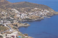
 Coastal Aghia Galini (left) This village, sitting at the western end of the Messara Gulf is a good example of what happens to lazy
Greek fishing villages when package tourism hits, this one wasn't even inhabited by Greeks for very long before tourism
first arrived during the 1980s. Villagers from Melambes and Saktouria moved down here less than a century ago, and the
population grew to about five hundred. With a harbor hemmed in by mountains, there isn't any good beach, but that hasn't
stopped the construction of hotels and apartment buildings Though an expensive place in general you can find some good
tavernas with good prices, and there's a campsite on the east side near the river mouth, to which you can walk from the
beach or reach via dirt road a little outside of the village. Sleeping on the beach becomes the only option for many, as it
can fill up in July and August. The Paximadhia islands, with good beaches, lie offshore, and to the west of the village are
the beaches of Aghios Yiorghios and Aghios Pavlos, accessible on foot (two hours to the first), or via boat . Aghios Pavlos,
is in a nice bay Needless to say, these places have tavernas and some rooms. To the east of Aghia Galini there is a main
road going first north a little ways and then southeast to the Messara plain in Heraklion province. Coastal Aghia Galini (left) This village, sitting at the western end of the Messara Gulf is a good example of what happens to lazy
Greek fishing villages when package tourism hits, this one wasn't even inhabited by Greeks for very long before tourism
first arrived during the 1980s. Villagers from Melambes and Saktouria moved down here less than a century ago, and the
population grew to about five hundred. With a harbor hemmed in by mountains, there isn't any good beach, but that hasn't
stopped the construction of hotels and apartment buildings Though an expensive place in general you can find some good
tavernas with good prices, and there's a campsite on the east side near the river mouth, to which you can walk from the
beach or reach via dirt road a little outside of the village. Sleeping on the beach becomes the only option for many, as it
can fill up in July and August. The Paximadhia islands, with good beaches, lie offshore, and to the west of the village are
the beaches of Aghios Yiorghios and Aghios Pavlos, accessible on foot (two hours to the first), or via boat . Aghios Pavlos,
is in a nice bay Needless to say, these places have tavernas and some rooms. To the east of Aghia Galini there is a main
road going first north a little ways and then southeast to the Messara plain in Heraklion province.
 To the west 30km/18.6miles, is Plakies (right), is an improvement over Aghia Galini, though it has become a tourist
destination in recent years. There are plenty of rooms, even in the cheaper categories, but high season is still high season
and they fill up fast. There's a youth hostel here, at the back of the town (most of which is, however, spread out along
the waterfront). The beach to the east along the bay is windy. To the west 30km/18.6miles, is Plakies (right), is an improvement over Aghia Galini, though it has become a tourist
destination in recent years. There are plenty of rooms, even in the cheaper categories, but high season is still high season
and they fill up fast. There's a youth hostel here, at the back of the town (most of which is, however, spread out along
the waterfront). The beach to the east along the bay is windy.
The best beaches are near olive groves farther to the east, walkable along a dirt road accessible from the main road, or
over the hill if you follow the beach. Both walks take more than half an hour, and the first you'll come to is Damnoni .
Unfortunately, this one has gotten built up quite a bit., and for seclusion you'll have to go beyond here to the cove beyond,
which has some caves in the rocks behind it. Bathing suits are dispensed with in these parts. Beyond there is Amoudhi
beach, which has a taverna and rooms. Lefkoyia,an inland village is a short walk from Ammoudhi, and is quiet place to stay,
away from the crowds at Plakias.
West Of Rethymno
North Coast: To the west is Souda Beach, which you can walk to in about half an hour along the coast (about 3km/1.86miles).
South Coast: Above Plakias is Mirthios, a small and friendly village , cheaper to stay in and with a youth hostel, and, though
farther from the sea, has the advantage of great views. There are good hikes from here. Beyond Sellia to the west are some
some coves, is the village of Rodhakino (which means peach), situated above a ravine, with the beach of Koraka (crow) down
below. This was the place where the German General Kriepe was taken off of the island to Egypt after being kidnapped by the
resistance during World War II. There are rooms here, a taverna , and Polirizio beach in the bay to the west, with more of
the same.
The Road from Rethymno to the south
This road goes just about due south and forks a little more than half of the way down, one fork heading south east to
Spili and Aghia Galini , and flanking the southwest side of the Kedros mountains on the west side of the Amari valley, another
fork heading south to Preveli and southwest to Plakias/ leaving initially from the center of the city of Rethymno.
 Whichever route you take, the scenery is fabulous. The Minoan cemetery at Armeni has been excavated, and many larnaxes (photo left)(burial chests/ clay coffins) found, as well as figurines and grave gifts. (open Mon-Fri 9am-3pm). Seven acres of chamber
tombs were found there, dating from the 2nd millennium BC. The finds from this site are on display at the archaeological
museums in Heraklion and Rethymno. The cemetery is in an oak forest. In fact, the area between the cemetery site and the
village is a forest conservation area with pine, cypress and oak trees. Whichever route you take, the scenery is fabulous. The Minoan cemetery at Armeni has been excavated, and many larnaxes (photo left)(burial chests/ clay coffins) found, as well as figurines and grave gifts. (open Mon-Fri 9am-3pm). Seven acres of chamber
tombs were found there, dating from the 2nd millennium BC. The finds from this site are on display at the archaeological
museums in Heraklion and Rethymno. The cemetery is in an oak forest. In fact, the area between the cemetery site and the
village is a forest conservation area with pine, cypress and oak trees.
The village of Armeni was named for Armenian soldiers who were given land grants here during the 10th century after
Nikeforos Phokas retook Crete from the Arabs.
 Spili is a nice town below a mountainside, with a wonderful Venetian lion
head fountain in the main platia (photo right), the water pouring out of the mouths of a long row of lion heads (nineteen, to be
exact). A cool shady place. There are nice winding streets in the upper part of the village with some old kalderimia
(cobbled streets). Spili is a nice town below a mountainside, with a wonderful Venetian lion
head fountain in the main platia (photo right), the water pouring out of the mouths of a long row of lion heads (nineteen, to be
exact). A cool shady place. There are nice winding streets in the upper part of the village with some old kalderimia
(cobbled streets).
From Spili you can walk to Gerakari in the Amari Valley, or to Lampini, where the Byzantine church was
burned by the Turks in 1827 (during the War of Independence) with the villagers inside. That fragments of frescoes remain
is a wonder.
Karines is a pretty village a little past here. There's a cave at Patsos which was a Minoan, Dorian, and Roman
sanctuary. There are nice walks in just about every direction from here that pass through lovely countryside and small
villages. From Spili, if you take the left fork at Asomatos, you'll be on your way to Preveli, continuing on straight will take you to
Myrthios and Plakias.
Below Levkoyia is one of the few rivers in Crete that flows all year, the Megapotamos, with a 19th
century bridge along the way. The Kourtaliotis gorge of this river is at the sea near Preveli, and at the mouth of the
gorge where the river empties into the sea there are sandy beaches lined with date palms, and pools upstream in the
river.
  The abandoned lower half of the monastery Moni Preveli (left) is here, called both Kato Preveli (right) and Aghios Ioannis. The abbot
here was collecting arms for a revolt here in 1821, at the beginning of the War of Independence, but the Turks heard about
it and came to destroy the monastery, but the abbot welcomed them and got them so drunk that they fell asleep, and the
monks escaped, but the place was sacked and burned. Today, the wooden ikonostasis remains amid broken walls, and there is a
shady courtyard. The abandoned lower half of the monastery Moni Preveli (left) is here, called both Kato Preveli (right) and Aghios Ioannis. The abbot
here was collecting arms for a revolt here in 1821, at the beginning of the War of Independence, but the Turks heard about
it and came to destroy the monastery, but the abbot welcomed them and got them so drunk that they fell asleep, and the
monks escaped, but the place was sacked and burned. Today, the wooden ikonostasis remains amid broken walls, and there is a
shady courtyard.
Piso Preveli, a short distance away and up on the bluffs has been largely preserved, as well as 17th
century icons there (open 8am to 1pm and 3pm to 7pm). During World War II allied troops were given food and shelter here
after the Battle of Crete and helping organize them for their rescue by submarine on beaches near the monastery (most likely
at Palm Beach (see below). A monument commemorates these events as well as offerings to the icon in the church.
Palm Beach is just to the east of the monastery and requires some effort to get down to by either foot or vehicle. A
lovely estuary oasis with palms and oleanders, it is best visited outside of peak season, when it not only gets very
crowded, but becomes also rather foul for lack of toilet facilities for the hordes of visitors. Garbage has also been a
serious problem, though hopefully by the time you read this, some improvements in this will have been made.
West of Rethymno
 The Old Road heads inland from the coast after a few minutes, heading towards Roustika with its nearby
monastery of Profitis Ilias, founded near the end of the Venetian period. The village is attractive, and there is a frescoed
church there. On the New Road along the coast is Yerani, and the nearby Yerani cave, which was discovered in 1967 when the
road was being built. The cave was a Neolithic sanctuary, where well-made obsidian and bone tools were found (shown in the
Rethymno museum). Also found were bones of the giant deer (strangely named 'dwarf deer'). The Old Road heads inland from the coast after a few minutes, heading towards Roustika with its nearby
monastery of Profitis Ilias, founded near the end of the Venetian period. The village is attractive, and there is a frescoed
church there. On the New Road along the coast is Yerani, and the nearby Yerani cave, which was discovered in 1967 when the
road was being built. The cave was a Neolithic sanctuary, where well-made obsidian and bone tools were found (shown in the
Rethymno museum). Also found were bones of the giant deer (strangely named 'dwarf deer').
Around here the road follows the
Almirou Gulf (Sandy Gulf) and there are sandy beaches right by the road as well, sheltered a little from the road and traffic
by oleanders. Swimmers should be forewarned that strong currents can be a problem here, and to take caution. Various
streams cross the road along here, which provide some good bird-watching. At this point you can see the White Mountains (Levka Ori) in front of you towards the west, as you approach the western boundary of Rethymno province on its coastal end a
little past the inland village of Episkopi The old road towards the latter is more scenic, however, with some nice
villages along the way.
 From Episkopi the road heads almost due south to the fascinating village of Argyroupolis (which means 'silver
city')., built on the site of ancient Lappa (right). There's little preserved of the ancient site, but the village very beautiful,
set above and on the slopes of the Mousselas river valley, which is filled with springs from which the city of Rethymno
gets perhaps a fourth of its water. During Venetian times, this town was a center for Cretan aristocracy. The red-tiled
roofs of the village are pitched, the slopes below them very green, and a lush green mountain looms up on the other side of
the river valley, giving the village the look of a place somewhere in the Balkans. A path leads down the wooded slope to the
pedestrian road along the stream below, with tavernas where one can sit and listen to the sound of the ubiquitous
springs. From Episkopi the road heads almost due south to the fascinating village of Argyroupolis (which means 'silver
city')., built on the site of ancient Lappa (right). There's little preserved of the ancient site, but the village very beautiful,
set above and on the slopes of the Mousselas river valley, which is filled with springs from which the city of Rethymno
gets perhaps a fourth of its water. During Venetian times, this town was a center for Cretan aristocracy. The red-tiled
roofs of the village are pitched, the slopes below them very green, and a lush green mountain looms up on the other side of
the river valley, giving the village the look of a place somewhere in the Balkans. A path leads down the wooded slope to the
pedestrian road along the stream below, with tavernas where one can sit and listen to the sound of the ubiquitous
springs.
The countryside near Argyroupoli is also worth exploring, with Myriokephala and its former monastery church of the
Panayia founded in the 10th or 11th century, which has Byzantine frescoes that are among Crete's earliest. There are
large-canopied trees in the village. Another road climbs to Asi Gonia at 400meters/1312feet, a village noted for its
traditional Cretan architecture, and which was the home village of author Yiorgos Psychoundakis, who wrote The Cretan
Runner, a book which describes the incredible rescue of the women of a village from execution by a German platoon by
guerrillas who fired on the platoon from a hill up above. There is a sheep-shearing festival here at the church on 23
April, where the sheep are brought at dawn, milked, sheared, and dedicated to Aghios Yiorgos, (Saint George) the village's
patron saint.
|
|
FEATURED PROPERTIES:Ikaria - Armenistis
New Maisonettes
Price: €209,000 - 125 m2
Bedrooms: 3 Baths: 2

|

